


There’s fresh snow in the Alps – again. This afternoon, the clouds are lifting across most areas after the second dose of chilly late-summer/early autumn weather in two weeks.
The first snow came on August 31. It was heavier than this latest episode, and in a few places there was over a half a metre of the white stuff. This time, most places had a dusting – although there have been heavier falls on the northern edge of the Alps in Switzerland and in the mountains to the east and south of Innsbruck. Above the Swiss resort of Engelberg there’s been around 20cm in the last 24 hours, and on the Hintertux glacier they’ve had 25cm (there was even 10cm in the valley this morning, at the bottom of the lifts). Last time we looked, it was still snowing – and the temperature was a wintry -7.6C.
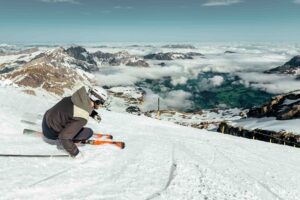
Here’s a sample of the lunchtime webcam shots.


It’s not going to last, of course. As the skies clear the snowline is already hurrying back uphill – and temperatures will be rising sharply in days to come. However, the mid-range forecasts are suggesting another cold snap in a week’s time – which is likely to bring more snow. Keep your eyes on the Welove2ski snow forecast over the next few days, to see if those predictions are accurate.
Of course, as we’ve said in recent Snow Reports, it’s impossible to know yet if this is going to add up to a snowy autumn – and a good start to the ski season: and we note that in western Switzerland Meteo Suisse is suggesting an average or warmer-than-average autumn. But we’re not un-hopeful. Weather patterns often set in for several weeks, and if a trend of snowy outbursts establishes itself then we could see snow starting to accumulate at altitude. Fingers crossed!
(Meanwhile across the Atlantic there’s been a dusting of snow on the highest peaks in Colorado – for example on Mount Baldy above Breckenridge.) However, what’s more remarkable is the fact that the trees in the mountains are turning, as the picture, below, from Aspen shows….


RT @welove2ski: Anyone willing to put money yet on a snowy start to the season? https://t.co/85bFhkSI
Fresh Snow in the Alps – September 13 https://t.co/YKFpgBri #alpen #schnee #snow #sneeuw #weer #wetter #bayern #alps #winter #weather #follow