


In the Alps, the week started mild and wet, with heavy snow at altitude. Now, temperatures have dropped, and the snow is still falling. Some places have had a metre of the white stuff since Sunday.
Saturday should see another snowy episode in the east.
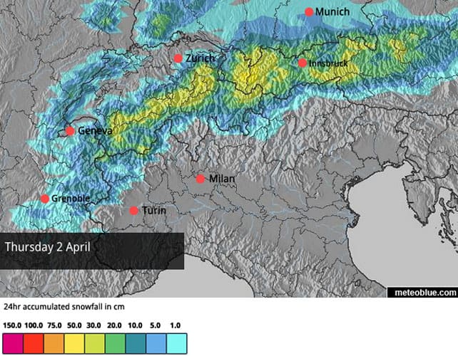
Here’s the today’s snow forecast for the Alps.
The drop in temperature is big change from Sunday and Monday, when it rained up to 2300m in the western Alps, and up to 2000m in the east. But even then, it was snowing hard at altitude. Accumulations over the last five days have been impressive. In the Haute Tarentaise, home to Val d’Isere and Tignes, 60-90cm have fallen since Saturday night above 2,200m (most of it on Sunday). In parts of eastern Switzerland nearly a metre has fallen this week. According to the Tirol’s avalanche service, there’s been even more than that in parts of western Austria, above 2000m.
In the last 24 hours alone, the upper slopes of St Anton have notched up 40cm of fresh snow, and the settled cover on the Valluga is up to 430cm deep.
It’s been windy too, and the avalanche risk has gone through the roof. In the Tirol, it’s 4/5 above 2000m, and there’s a lot of cold, unstable, wind-blown snow around at altitude. Off-piste skiing is out of the question until it settles.
In France, the avalanche risk has dropped back a little. Most of the snow fell in the milder storm on Sunday and Monday, and it was for the most part wet and heavy. The drop in temperature has forced it to refreeze, and it’s more stable as a result. And thank goodness for that: in the Savoie, a staggering 250 avalanches were recorded in 48hrs at the start of the week. Great caution is still needed away from the groomed slopes, however, as the danger level is still considerable in many places: 3/5.
On piste, the new snow has improved conditions everywhere across the northern Alps. In the west, however, the really cold wintry snow is thinner than in the east, and thanks to the wind will have been blasted off some pistes completely: so you will find icy stretches below 2300m.
In Austria, the cold snow is still falling in quantity, so – if you can see where you’re going – the cover is likely to be more consistent. As is always the case at this time of year, the best conditions will be above 2500m whenever skies clear. All in all, it’s an extraordinary turnaround.
Below is a sample of today’s webcams. You’ll notice there’s generally more sunshine around in the west than the east. High pressure has settled over the Bay of Biscay, and it’s keeping the meat of today’s snowstorm off the western end of the Alps. It’ll make temperatures a little warmer too, though even here the freezing point will be at 1500m, which is low for the time of year.
Next week is likely to start sunny and a little milder. But there’s the chance of more snow in the east on Tuesday.
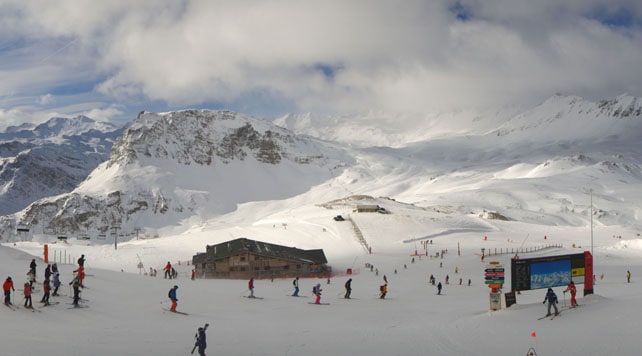
Pictured below was Val d’Isere earlier this morning. Here, the snow is currently 100-195cm deep.
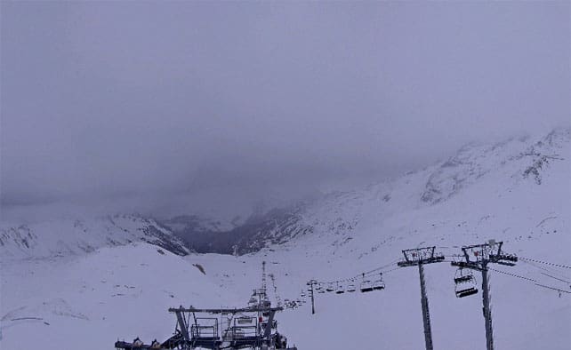
Pictured below is Les Arcs, where the snow is currently 58-198cm deep. This webcam shot is an hour or two later than the one from Val d’Isere, and the weather’s clearly closing in for a while.
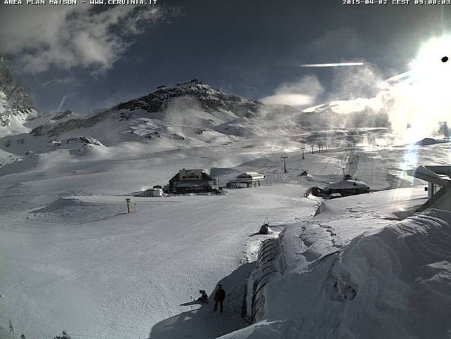
Pictured below is Cervinia in Italy, first thing this morning. Most of Italy has missed out on this week’s snowfall. However resorts right up against the French, Swiss or Austrian border have seen moderate or even heavy falls. There was, for example, half a metre of fresh snow above Cervinia on Monday. Current snow depths range between 40 and 300cm.
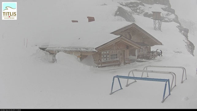
Below is the Stand ski hut above the Swiss resort of Engelberg. There’s 220cm of snow packed down here, and 330cm up on the glacier.
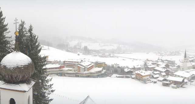
Pictured below is Ellmau in the Skiwelt in Austria. The scene here was very spring-like last week. Not anymore. However, at this low altitude, the new snow has had less of an impact, and the cover is only 20cm deep on the valley runs.
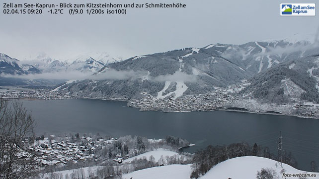
Pictured below is Zell am See, further east in Austria. Snow has been falling right down to lake level over the last couple of days, but as is the case everywhere in the Alps, you want to be skiing at altitude to get the full effect. Up on the Kitzsteinhorn glacier, in the background, the snow is currently 340cm deep.
Meanwhile, across the Atlantic…
After a generally disappointing winter, Whistler is having a decent spring, with several top-ups on the upper slopes in recent weeks – including 26cm on Sunday and Monday. Total fresh snow for the past week has been 47cm, and the current snowpack is 180cm deep. Snow showers are expected over the weekend, but they won’t add up to more than a few cm of new cover. Conditions have improved in the Canadian Rockies too: Lake Louise has had 30cm of new snow in the past seven days and daytime temperatures are back below 0C, which is what you’d expect here in early April.
| France: the heaviest snow in France was the stuff that fell at altitude on Sunday and Monday, before temperatures dropped. Since then, there has been snow, but not in the quantities seen in Austria and eastern Switzerland. That means a fairly complicated picture as far as current conditions go. Up high, there’s great snow, although it is wind-blown and avalanche-prone, off-piste. Lower down, below 2300m, the underlying cover is hard and refrozen, with a thinnish layer of new snow on top – which is a recipe for icy patches on the lower pistes. Even though the freezing point is reported at 1500m today, however, south facing pistes will be softening whenever the sun comes out.
In France, the next few days are likely to be sunnier and slightly milder than in the east. If you’re planning a last-minute dash to take advantage of the dramatically-improved conditions, then aim high. Currently in Val Thorens in the Three Valleys there’s 150-250cm of settled snow on the pistes, and in the Chamonix Valley, the Grands Montets sector reports 150-180cm of settled cover. |
|
| Switzerland: it’s been a cooler and snowier second half of the week in Switzerland than in France, and conditions are generally more consistent. The best snow is at altitude, but even at lower altitudes the cover is much improved, even if it is still thin. Currently Verbier in the west reports a mid-mountain snow depth of 185cm, and 295cm at the top, while St Moritz in the south has 26-158cm of cover across its pistes. | |
| Austria: the storm hit Austria a little later than France, but has stuck around for longer, dropping heavy snow yesterday and today. You’ll still have to ski at altitude to get the most consistent conditions, and stay on the pistes for safety’s sake. But if you do you should be treated to superb wintry snow whenever skies clear. Currently, in the Arlberg, Lech has 90-235cm of cover, on piste, and on the Hintertux glacier it’s up to 270cm deep. Meanwhile, further east, the Schladming reports 70-140cm of settled snow, on-piste. | |
| Italy: there was widespread snow across the Italian Alps last week, but most resorts have missed out on the big dumps this week. Only those close to the northern frontier have benefitted. Above the Aosta valley, Champoluc currently has cover 25-190cm of cover, on-piste. Meanwhile, in the east Canazei in the Dolomites reports 40-120cm of settled snow on its slopes. | |
| Andorra: it’s a mild and sunny day in the Pyrenees, thanks to the influence of high pressure over the Bay of Biscay. In the Grandvalira ski area, for example, top temperature is likely to hit +7C at 2000m. Currently, the snow is 90-170cm deep on the pistes. | |
| Western USA: there is likely to be some fresh snow over the Rockies in the next few days. Colorado should get some on tonight (Vail might get 15cm, for example), and the northern Rockies should see snow on Sunday and Monday. But in neither case will there be enough to alter the fact that spring sprang early here, at the beginning of March, and has been difficult to shift. Snowfall totals for March were a long way below average as a result. Currently, in Vail, Colorado, the mid-mountain snowpack is 122cm deep, and the daytime high is expected to hit +7C. In Utah, Snowbird has 175cm of settled mid-mountain snow, and it’s slightly cooler today. There may even be some snow. | |
| Western Canada: Whistler’s Easter is looking good, thanks to all the top-ups of snow this week. Coolish temperatures (by April standards) should keep it in decent condition, too. The mid-mountain snowpack there is 177cm deep. Inland, in Fernie is approaching its final week of winter operations and has had 14cm in the last seven days. Currently, the snow pack there is 156cm deep. The temperature at the base of the lifts should hit +8C. |


hey Sean-hope you are well-we are off to Les Arcs tomorrow-remember 1950 with Sam? Chris
Chris!! What perfect timing for a trip…Yes of course I remember Arc 1950. And Courchevel 1998 too…Holy cow, that was a holiday. I thought I’d died and gone to heaven.
Enjoy the snow!