


What a relief! After a month-long snow-drought, the weather in the Alps is turning: and if the forecast for the coming five days is anywhere near accurate, we should see significant snowfall in parts of the Alps and the Pyrenees.
In the Alps, the resorts of France and western Switzerland should do particularly well during the early stages of what could be a whole week of snow.
Change is already in the air. Except in the east, the sun’s gone, and the first flakes are falling across the Mont Blanc massif as I write. As you’ll see from Welove2ski’s snow forecast, there should be light snowfall at altitude across the Alps today and tomorrow, before heavier snow hits the western end of the region on Saturday. The white stuff will spread east on Sunday before an even meatier storm moves in on Monday.
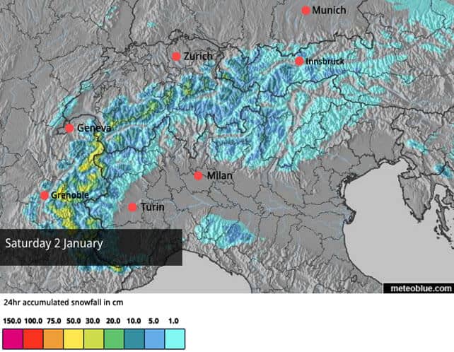
Here’s the latest forecast for Saturday.
And this is Monday’s snow map.
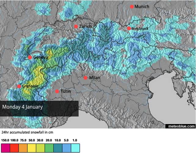
At this point I should stress that the detail of the forecast will probably change over the next couple of days, as it has been all week. For example, it’s only today that our snow maps have started to promise heavy snow on Saturday.
Nevertheless the broad outline seems clear. High pressure has loosened its grip over the region, and we’ll see a series of weather fronts, sweep across the region over the next few days. The whole of the northern Alps will be affected, but France and western Switzerland will see the heaviest snowfall – in the short term at least. The Arlberg in western Austria (home of St Anton, Lech-Zurs and Warth-am-Arlberg) will see moderate accumulations too. It looks as though some snow will also fall in the Aosta Valley and the Dolomites in Italy.
One feature to bear in mind is that temperatures will be yo-yoing up and down over the next few days, and at time the snow/rain line will be quite high. It’s likely to get more consistently chilly in the early days of next week. But in a winter that’s been as mild as this your best bet is to play it safe, and aim for a resort with plenty of skiing above 2000m, so you can be sure of a soft and wintry skiing surface.
According to some of the mid-range forecasts, there could be another significant dose of snow in ten days’ time, over the weekend of January 9/10 – which this time will favour Austria. But it’s much too soon to be certain of that, and even if it comes there are likely to be milder spells in between.
Needless to say, after such a poor start to the winter, the new snow will be a real tonic. Right across the northern Alps the pistes will be vastly improved by the addition of softer, grippier natural snow – although on steeper pistes it will probably be scraped away to reveal the hard-packed surface underneath in the early days of the storms.
In the west there may even be enough snow to fill in the less rocky off-piste runs. The avalanche risk is also likely to rise significantly in the short-term, and you’ll probably find your skis are still scraping the odd bit of rubble. In these conditions, anyone searching for powder should hire a guide: not just to keep them safe, but to lead them to the parts of the mountain where the snow is deepest.
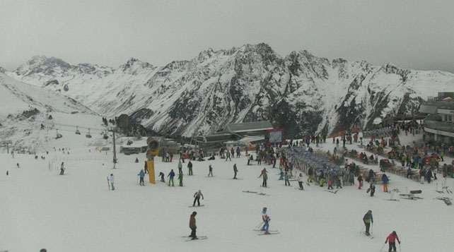
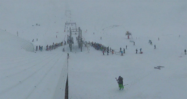
Here’s a quick squizz at the webcams this morning, starting with Ischgl in Austria, which has once again coped well with a snow drought – thanks to its state-of-the-art snow-making system (it was the same story in the early weeks of the 2014-15 season).
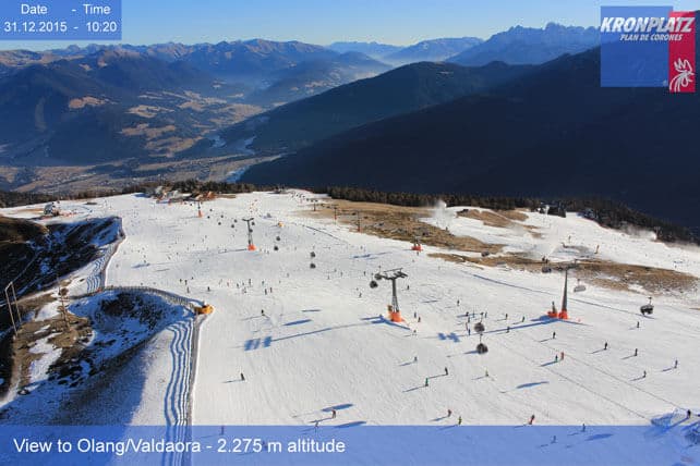
Pictured below is the scene at the top of Kronplatz on the northern edge of the Dolomiti Superski collective of resorts in Italy. As you’ll see, there’s very little natural snow here – as is the case right across the Dolomites. But the resorts have done a fantastic job with their snow cannons, and between them they’ve opened 787km of pistes. Light snowfall is expected in the region, with a few resorts, such as Madonna di Campiglio in the Brenta Dolomites, likely to get a bit more than that.
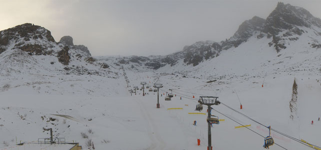
Pictured below is the glacier above Les Deux Alpes this morning. In common with all the French resorts south of Grenoble, Les Deux Alpes has had little in the way of natural snowfall so far this winter, and on the lower slopes its pistes are ribbons of white against the grass. Under the circumstances, the glacier has been a real boon. However, heavy snow is now expected at altitude here on Saturday, and again on Monday.
Pictured below is the Double M piste at Tignes, which shares its ski area with Val d’Isere. Here too, they should see a very healthy top-up of snow in the next five days.
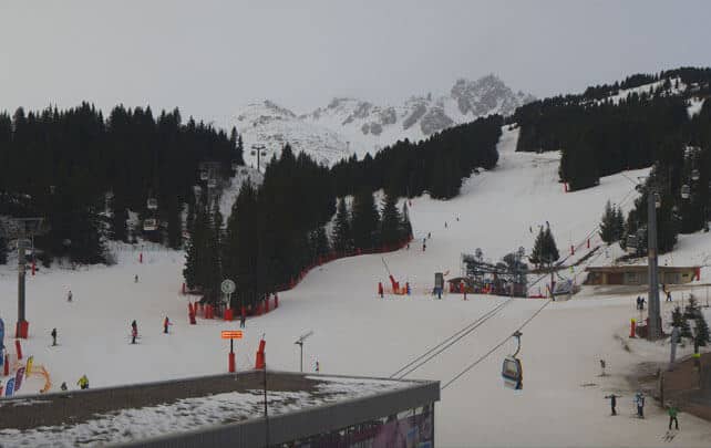
And here’s the Croisette at Courchevel, where good work with the snow cannons has kept the pistes skiable through the mild, snowless days of December. Now, moderate to heavy snow is expected, which is great news for me as I’ll be in the resort next week.
Meanwhile, Across the Atlantic…
Regular followers of the Snow Report will know that December has been a spectacular month across the resorts of the western USA, and in parts of Canada too – with most of the key regions getting walloped repeatedly by big snowstorms. Several resorts around Lake Tahoe have had more than five metres of snow already – which is what most Alpine resorts would hope for in an entire season – and little Wolf Creek in southern Colorado has notched up a whopping 642cm.
The latest beneficiaries of the munificent December weather have been the inland resorts of British Columbia, which woke to a powder day last Saturday.
Here’s how it was in Big White.
And this was the scene in Sun Peaks.
In recent days the weather has become a lot more settled and sunny. There have been a few more dustings of powder in places, and of course the snowpack is deep for the time of year almost everywhere in the west. But the powder party is over for the time being.
Next week sees a new pattern developing. As everyone knows by now, the occasional Pacific-Ocean climate anomaly known as El Niño is now well-established, and is having all manner of impacts. In the coming days, forecasters are predicting the development of a “classic” El Nino weather pattern, with high pressure over the north-west and a series of storms piling into the south-west.
The Californian resorts should do well from this set-up, and we could see another spectacular run of storms here – rolling on into southern Colorado and New Mexico.
| France: Christmas and New Year have been very far from spectacular in France: but at least in the Tarentaise most resorts have managed to open half of their pistes. Now, all eyes are on the forecast – which should bring heavy snow right across the region, both north and south of Grenoble. Beware of the wavering snowline, though. There could be rain up to 1500m at times, maybe higher, so if you want the best conditions, aim high. Currently, the best cover is in the high-altitude resorts of the Tarentaise, where Tignes, has 29-60cm of settled cover, on-piste and Val Thorens has 45-90cm. However, with the clouds coming in, visibility is deteriorating. | |
| Switzerland: conditions across the northern and western resorts of Switzerland are quite similar to the northern resorts of France: the higher resorts look almost wintry, although the cover off-piste is generally too thin to be skiable and the pistes are firm. In the south-east the cover is thinner. The best snow will be up on the glaciers, in resorts such as Saas Fee and Zermatt. Currently, Zermatt reports 125cm of cover at 2900m. The western resorts and northern are going to do well from the coming snow – those in the south-east less so. | |
| Austria: the best snow in Austria is to be found on the glaciers at the moment, although Ischgl, and the resorts of the Arlberg in the west are in reasonable shape too. Amazingly, low-lying ski areas in Austria have also managed to open a fair number of pistes: in the Skiwelt for example 137km of pistes are currently skiable. The glacier ski areas include Hintertux, the Molltal, the Pitztal, the Kaunertal, the Stubai, the Rettenbach, above Solden, the Kitzsteinhorn and the Dachstein. Austria is likely to get less snow than France or western Switzerland, but the Arlberg should do fairly well from the storms, and there’s hope of another snowy spell in ten days’ time. | |
| Italy: most Italian resorts are still waiting for the their first significant snowstorm. However, brilliant work by the snow-making and grooming teams have ensured that pistes have opened with little help from Mother Nature – especially in the Dolomites. Decent skiing on firm pistes is also to be found in high-alitude areas such as Cervinia, the Presena glacier above Passo Tonale. | |
| Andorra: the snow drought (and prolonged thaw) hit the Pyrenees hard, too, but they’re expecting plenty of snow in the next four or five days. In the Grandvalira ski area, Pas de la Casa has up to 50cm of snow packed down, on-piste. 128km of pistes are open across the ski area, which is a remarkable achievement given the unhelpful weather so far this month. | |
| Western USA: see our main report. The resorts of California, Utah, Colorado and Wyoming are in great shape at the moment, although the powder party is now over. Currently, in Colorado, Breckenridge reports 94cm of mid-mountain snow, in Utah Snowbird has 142cm, and Heavenly 160cm. High pressure has now settled over the Rockies – but there is hope of significant snow for California next week.. | |
| Western Canada: Whistler has had a cracking December, and has 177cm of snow packed down, mid-mountain. However, the sun is now in control and temperatures are mild, so the lower runs will be firm in the mornings and at the end of the day. Inland, in Banff National Park, Lake Louise has had a 7cm sprinkling of snow in the last week and has a mid-mountain snowpack of 77cm. |


Add Comment