


Stone the crows, Stonefiends. It looks as though winter is making a comeback.
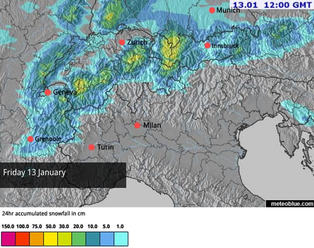
After a stinking week of spring-like weather in the Alps, the next three days will see a drop in temperatures and fresh snow in many places. It looks as though the eastern end of the Italian Alps will see the heaviest falls, with up to half a metre settling in places tomorrow. France, eastern Switzerland and western Austria should see 10-20cm as well. By contrast, the northern resorts of Austria will get only a dusting, which is a shame, because this is where the snow is needed most.
Here’s Welove2ski’s Alpine snow forecast for tomorrow. Note that the freezing point will be down to about 1300m tomorrow, which is not exactly frigid, but a lot cooler than it has been of late.
More snow is expected at the weekend and, possibly, at the beginning of next week, too. By the time the skies clear, the damage done by the recent thaw should be a fading memory – with the pistes soft and grippy again. Currently, much of the skiing below 2000m is hard-packed and icy in the mornings, before it softens at lunchtime. On sunny slopes you’ll find similar, spring-like conditions up to 2500m or more.
At lower altitudes the snow is thin, too. In many places, the pistes are relying heavily on snow cannons and grooming machines for their cover.
Even after the fresh snow I would still advise aiming high if you’re planning a last-minute January trip. This has been a mild winter so far, and there’s no sign yet of a really profound change to that picture.
At least the warmth has allowed the snowpack to settle and stabilise off-piste. Readers of recent snow reports will know that Christmas and New Year saw a grim sequence of avalanche fatalities, thanks to unusually unstable conditions off-piste, and it’s good to to see that in many places the avalanche risk has settled back to 2/5. However, given the recent spate accidents, off-pisters would be well-advised to err on the side of caution, especially with fresh snow coming in.
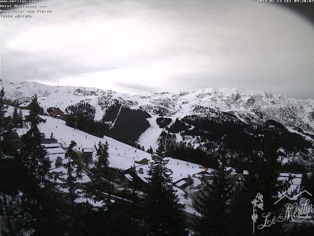
You can almost feel the snow about to fall in this shot from Meribel this morning.
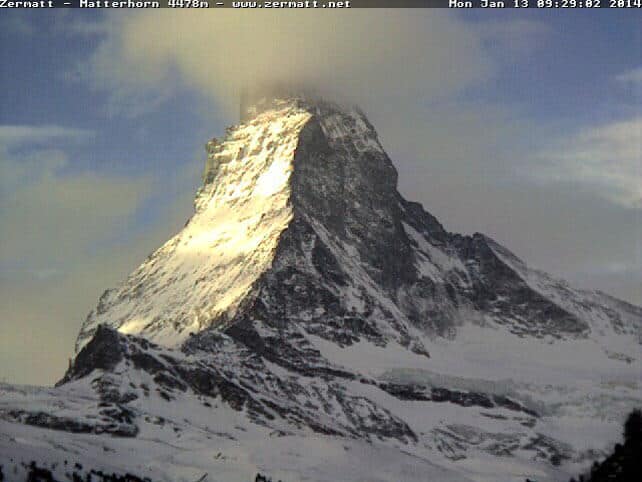
Meanwhile in Zermatt, the Matterhorn has got its cloudy hat on today, in anticipation of the coming snow.
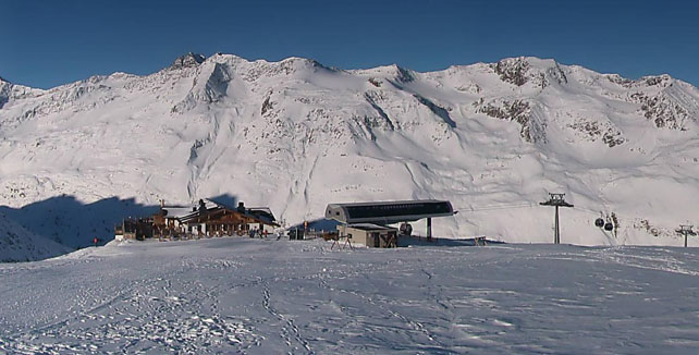
Further east, however, the sunny weather will stick around till this afternoon. Pictured, below, is Obergurgl in Austria.
Meanwhile, look at what I missed in Utah…
I was skiing in the Canyons in Utah last week. But I’ve been banging my head on my desk since I got back, because look what happened just after I left…
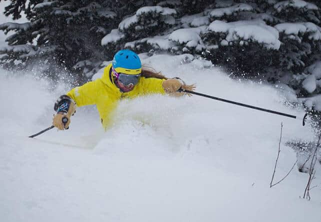
This was the amazing Kaylin Richardson making the most of the new snow on January 10. There’s been more snow since then: in fact it’s had about 45cm of the stuff since I left on Wednesday morning last week. Which is NOT FAIR.
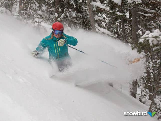
And the picture below is from Snowbird – which is a couple of valleys to the south of the Canyons. It shows skier Hannah May enjoying some of the 105cm of snow that’s fallen there in the same period.
There’s been plenty of snow in Colorado and Wyoming, too: Jackson Hole in Wyoming reported 40cm of snow over the weekend, and in Breckenridge, Colorado they had 25cm yesterday, bringing the weekly total to around 90cm.
Here’s the latest video from Breckenridge…
Sadly, this run of storms is now expected to grind to a half – with 10 days of dry weather on the cards.
Whistler has had a proper dump at last
It’s been a long time coming, but Whistler has had a proper dump at last: notching up 70cm of snow at the weekend. Mid-mountain snowdepths there now a lot closer to what they should be at this time of the year – 166cm.
| France: The fresh snow due in this afternoon and tomorrow will be sufficient to refresh the pistes – especially above 1500m. By the time it’s been groomed in, the cover will be soft and grippy again. However, it doesn’t look as though it will be enough to make a difference to conditions off-piste, which is crusty at lower elevations and on south-facing slopes. The snow forecast for the weekend should help to repair the situation further: but all the same, it’s best to aim for a high-altitude resort at the moment to be sure of decent skiing. Currently, Les Deux Alpes has 15-180cm of settled cover, on-piste, Val d’Isere has 64-105cm, Val Thorens has 100-160cm, and Serre Chevalier has 40-105cm. | |
| Switzerland: As in France, you need to aim high to be sure of good skiing – although the coming snowfall should improve the pistes at all elevations. In Andermatt the snow report records 50-350cm of settled-cover, on-piste. Elsewhere, Laax the settled cover is 20-130cm deep, in Davos it’s 25-90cm deep and in St Moritz it’s 88-135cm deep. | |
| Austria: It’s a winter of two halves at the moment: top half, and bottom half. Up high, especially in the east Tirol, and along the Italian border, the snow is deep and magnificent. Further north, and lower down, it’s non-existant, with the valley runs little more than ribbons of white against the grass. Let’s hope they get a decent dump here soon. In Obergurgl the settled cover is 75-180cm. The snowpack on the Stubai Glacier is up to 210cm deep, too. Meanwhile, the Skiwelt reports cover only 20-40cm deep. Here, less snow is expected over the coming days than in the resorts further west and south. | |
| Italy: The snow is still deep in many resorts in the central and western Italian Alps – and more snow is expected, this time favouring the east. Currently, above the Aosta Valley Cervinia reports 80-160cm of fresh snow, and in Madesimo it’s even deeper, thanks to over 2m of snow at altitude from the Christmas storm. Further east, in the Dolomites, there’s 35-125cm snow above Canazei. | |
| Andorra: Thanks to heavy snow in November, the Pyrenees got off to a cracking start to the season – and there was heavy snow at Christmas, too. Last week was warm, but in Andorra, Grandvalira reports a healthy 80-160cm of settled snow, on-piste. | |
| Western USA: See our main report. The Rockies have had an excellent five or six days, although now it looks as though a dry spell will settle across the region for a week or more. California had a dusting too – but it needs a lot more than that to catch up with where it should be. Currently, Breckenridge has 155cm packed down, mid-mountain, Snowbird has 177cm, and Jackson Hole 142cm. | |
| Western Canada: At last, Whistler has had a proper dump: 70cm at the weekend, bringing its mid-mountain snow depths up to 166cm. Elsewhere, Lake Louise in Banff National Park reports 23cm of new snow over New Year and a mid-mountain snowpack of 127cm. Revelstoke reports 15cm of fresh snow and a mid-mountain snowpack of 189cm. |


Welcome back, winter. We were missing you. https://t.co/EbTe9pLpDq https://t.co/eBRsTQa0xB