


It’s going to be a beautiful day. The sun’s out, it’s cold, and the snow’s in fantastic condition almost everywhere across the northern Alps, in the wake of a two-week spell of unsettled weather which came to an end a couple of days ago.
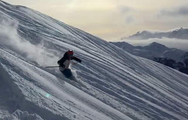
For a taste of how good conditions are right now, here’s Barney Hardy of the Warren Smith Ski Academy on the slopes of Verbier yesterday.
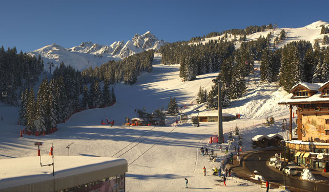
And here’s how it’s looking this morning in Courchevel in the Three Valleys of France.
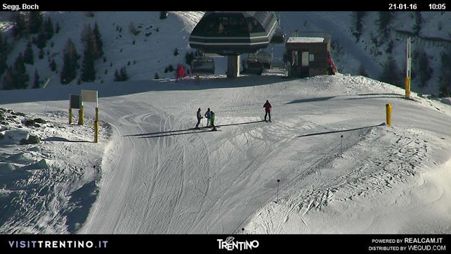
Pictured below is the scene in Madonna di Campiglio, in Italy’s Brenta Dolomites. In contrast with the northern Alps, the resorts of the Italian Dolomites have had a largely snowless season. However, unrelenting work with the snow cannons means that many pistes have been skiable. In Madonna, this work was supplemented last week by a 40cm top-up from Mother Nature.
Meanwhile, pictured below is the very wintry scene earlier this morning in Kitzbuhel. The Tirolean resort is readying itself for the biggest race in World Cup skiing – the Hahnenkamm downhill
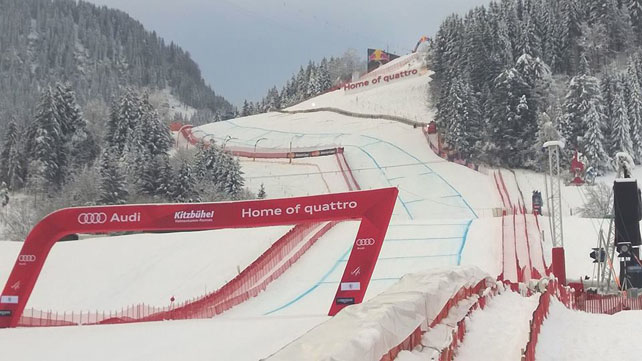
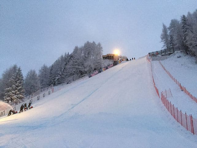
Today is the last day of training. Tomorrow sees the Super-G and Slalom Combined, with the downhill due on Saturday. It’s a shame the big race isn’t tomorrow, when the sun will be shining. On Saturday a weather front will graze the northern Alps, and it’s likely to be overcast with a few flakes of snow/spots of rain about to make visibility less than perfect.
Here’s Saturday’s snow forecast, showing Kitzbuhel’s location.
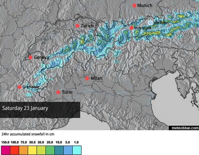
Our snow forecast is also showing moderate to heavy snowfall in the eastern half of Austria on Sunday – although the mid-range weather models are today not in agreement about that. High pressure could take hold; or it could be more changeable. However the forecasts do agree that temperatures will be rising sharply. The beginning of the next week could see spring-like warmth, with the freezing point in Austria up to 2700m.
As a result, a 24-hour cycle of daytime melting/overnight refreezing is likely to take hold on sunny slopes and at lower altitudes – which means crusty cover off-piste and hard-packed cover on the groomed trails first thing in the morning. If you’re planning to ski next week, you might want to get your edges sharpened, or else jump on a lift to the highest slopes in your ski area, and stick to the shadiest runs.
Meanwhile, in North America…
The weather’s been busy in the western resorts of both the USA and Canada – with the snowstorms coming thick and fast over the last week. Several resorts have had over a metre of fresh snow as a result.
California has seen some of the heaviest falls. In the 8 days up to Wednesday, Northstar reported 132cm of snow and Sugar Bowl a whopping 162cm. However, on Tuesday things the weather warmed up – and the cover became wet and heavy on the lower slopes as the snow turned to rain. Thankfully, it is due to cool down over the weekend. The Tahoe resorts are expecting up to 60cm of snow from the next big storm.
There’s been snow inland, too: yesterday, in Utah, Snowbird reported 127cm of fresh snow in five days up to January 19.
Here’s how it was when the sun came out…
In Colorado, Vail has had 90cm of snow in the last week – most of it in a big, 60cm two-day dump at the weekend.
Here’s how it was looking on Sunday.
And here’s a rather tasty video from Breckenridge, Colorado – filmed on Saturday…
| France: there’s plenty of snow in the French Alps, with good cover right down to village level in the lower resorts. However, the weather will be much less snowy over the next few days. There will perhaps be dusting on Saturday, but generally the outlook is sunny and increasingly mild. Off-piste, there’s still a considerable avalanche risk, although the snow is beginning to settle. Currently, Tignes, has 102-183cm of settled cover, on-piste, and Chamonix 150-240cm on Flegere. | |
| Switzerland: conditions across the northern and western resorts of Switzerland are quite similar to the northern resorts of France: there’s excellent cover almost everywhere, and the snowpack is beginning to settle. However the risk off-piste is still 3/5. Currently, Verbier, reports 24-180cm of cover, on piste, and Engelberg 80-310cm. | |
| Austria: Austria didn’t get as much snow from the early-January storms as France and western Switzerland, although resorts in the Arlberg such as Lech, were an exception. However, moderate to heavy snow last weekend transformed conditions. Currently, the Skiwelt has 55-75cm of cover, and St Anton 70-150cm. | |
| Italy: still the watchword is “more snow please” in the Italian Alps, although the scene is not nearly as snowless as it was a couple of weeks ago. Currently, high-altitude Cervinia reports 65-180cm of settled snow. In Canazei in the Dolomites it’s 25-60cm deep. | |
| Andorra: the Pyrenees didn’t get as much snow in the first half of January as the north-western Alps. In Andorra, Pas de la Casa has up to 70cm of snow packed down, on-piste. | |
| Western USA: see our main report. Conditions are very good across the Rocky-Mountain resorts right now. Meanwhile, in California, they’re waiting for the weather to cool down after a rather mild and soggy middle of the week. Currently, in Colorado, Breckenridge reports 132cm of mid-mountain snow, in Utah Snowbird has 203cm, and in California Heavenly has 185cm. | |
| Western Canada: Whistler is in good shape at the moment, with 20cm of fresh snow and a mid-mountain snowpack of 207cm. More snow is expected today, although it will be mild – which means rain on the lower slopes. In Banff National Park, Lake Louise has had a drier week. There’s been 16cm of snow in the last seven days, and the mid-mountain snowpack is 87cm deep. |


Add Comment