


At last: a proper, mid-winter snowstorm has appeared in the Alpine forecast. It’ll be carried in on frigid, northern air, and will bring snow to even the lowest villages and valleys. Half a metre or more could fall in places.
However, in the Alps, it’s going to be restricted almost exclusively to Switzerland and Austria. The French resorts are likely to see only a dusting, and the same goes for the whole of the Italian Alps.
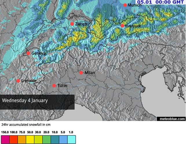
Here’s the latest Welove2ski snow forecast for tomorrow, January 4.
And this is the snow map for January 5.
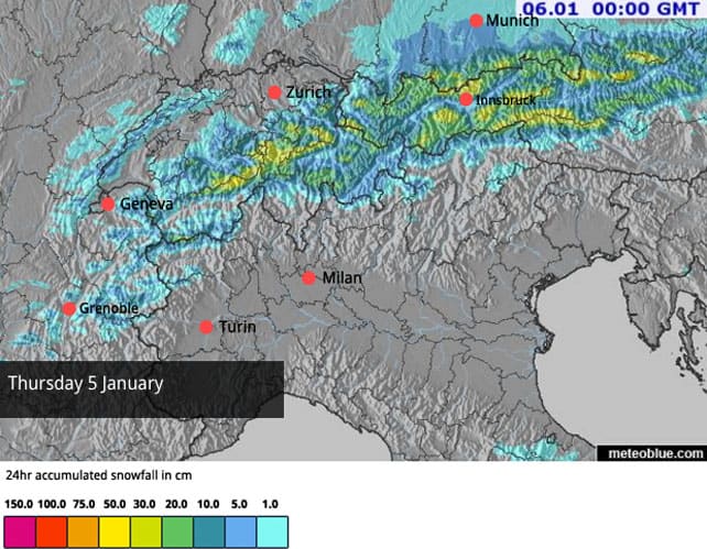
Impressive, huh? This is a classic weather front from the north, and all the usual suspects are in line for a dump – including Engelberg, Laax and Klosters in Switzerland, Lech and Warth in the Arlberg (and, to a lesser extent, St Anton, on the other side of the new Flexenbahn lift), the Nordkette by Innsbruck, Kitzbuhel in the northern Tirol, Hochfugen and the Hintertux in the Zillertal, and Saalbach, Kaprun and the Kitzsteinhorn. Areas further east such as Schladming, which had 25cm of snow last week, will also benefit.
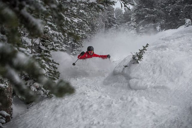
The snow will be cold, dry, and light – not quite what the Americans would call Blower Pow, but not far off. It will be heaven to ski, off-piste – provided it’s deep enough. But there will be a high avalanche risk in the early days, thanks to strong winds, and the fact that in many areas it will be falling on bare ground or slick sun-baked snow. Skiers will need to take avalanche warnings very seriously – and bear in mind that in some areas they may find themselves scraping through to the underlying rocks.
Nevertheless, it’s an exciting time – especially as temperatures will be staying low in Austria for several days after the storm. The mid-range forecasts are even suggesting a second helping next week (which may also bring snow to Italy), although you can’t bet on it just yet.
Further west, I’m afraid it looks as though high pressure and mild daytime temperatures will continue to dominate. Here, the snow cannons will continue to be the source of most of the snow, and skiers should focus their attention on high-altitude resorts such as Tignes, Val d’Isere, Val Thorens and Cervinia, and those which did well out of the patchy snowfall of late November and early December in the southern French Alps and the western Italian Alps. These include Montgenevre, Serre Chevalier, Sestriere, Sauze d’Oulx, Champoluc and Pila.
There’s precious little lift-serviced off-piste skiing in these resorts that hasn’t already been skied to ribbons, but they do at least look properly wintry, and have masses of piste-skiing on offer, even if the skiing surface is hard-packed on many runs.
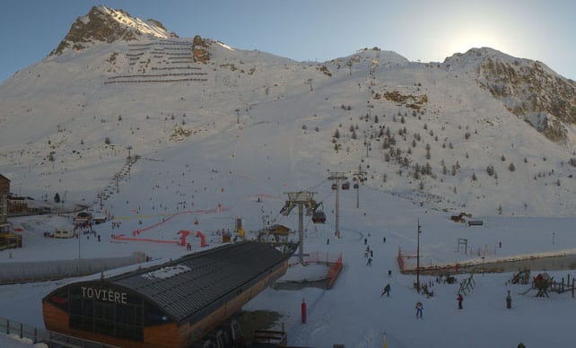
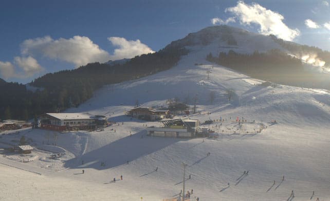
Here’s how it’s looking today in high-altitude Tignes. The snow here is currently 40-130cm deep.
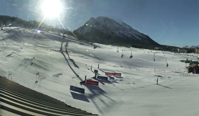
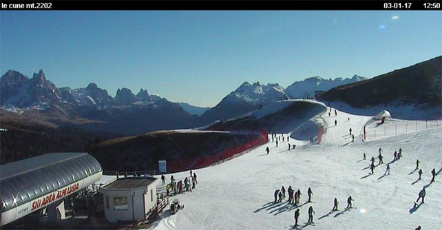
Pictured below is Montgenevre further south – one of the winners of the early-season snow lottery – which had fresh snow in late November and the week before Christmas, along with the Italian resorts of the Milky Way. Here the cover is 90-200cm deep.
Pictured below is Soll in the Tirol – part of Austria’s Skiwelt. Despite a dearth of natural snowfall, they’ve worked their snow cannons hard here, and have over 200km of piste open. What’s more the area is line for moderate to heavy snowfall over the next two days.
Finally, these are the slopes above Moena in the Italian Dolomites. They’re part of the Dolomiti Superski area, which has done an extraordinary job with its snow cannons this year. Natural snowfall has been light and sporadic (fifola, as they say in these parts): but all the same over 1,000km of pistes are open.
Meanwhile, in North America…
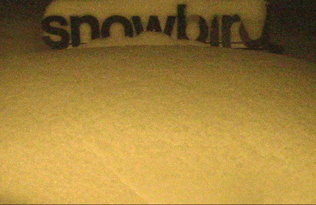
There’s deep snow in the Wasatch mountains of Utah today, thanks to a weather front that stalled over the region yesterday. Pictured below was the Snowbird yesterday.
And this was the resort’s snow stake in the small hours of the morning, with the 16 inch/40cm marker totally covered.
Local snow guru Evan Thayer is forecasting another storm of similar intensity from tonight until Thursday, and yet more at the weekend. “Get ready to take some “sick” days… hell, just quit your job, it’s going to be unreal,” he says.
Meanwhile, in California, they’re battening down the hatches around Lake Tahoe in preparation for something remarkable. On Monday morning, OpenSnow forecaster Bryan Allegretto reported 10-30cm of snow in the mountains around the lake. By the end of Thursday he’s expecting 90-150cm more…


I am booked for a trip to Les Gets with friends on 14/1; but could easily head to St Anton instead. I am seriously considering the latter right now; what does the long range and your gut suggest? I think i know the answer but dumping a freeish trip for a last minute dash, potentially on my own, i wanted a second opinion! Thanks Andy
Hi Andy – that’s a tough call! How soon do you need to make your decision? And what are your skiing priorities?
This morning (Wednesday) the ECMWF chart at meteociel.fr is suggesting there could be a cold and snowy spell across the whole of the northern Alps, starting January 14. It’s much too soon to be sure of that, but over the next week you’ll be able to follow the forecast and see if it firms up – or not. If it comes, it may not be enough to open up the off-piste terrain in the Portes du Soleil, but it would help open up more pistes. According to morzine-avoriaz.com, only one sixth of the PdS’s pistes will be skiable today. They desperately need a change in the weather…
In the meantime, I’d wait to see what the next two days bring. Les Gets will see a little snow, but it’ll probably be a dusting compared to what falls in the Arlberg, and there’ll be a few days of mild sunshine to follow, so some of what falls will melt. You need to double-check that St Anton gets the promised snowfall too. Let’s not forget that it has been relying on its snow cannons too, and the cover off-piste has been very thin. It needs a couple of dumps before the rocks are covered.
In other words – I’d delay the decision a couple of days at least. If off-piste skiing is a priority, then St Anton looks much more promising than Les Gets at this stage. If you’ll be sticking to the pistes, St Anton is also a much safer bet, although Les Gets may get a dump just in time to open up the PdS properly for your trip.
There are also the important considerations of cost and whether or not you fancy skiing without your friends for a week! As I said, it’s a tough call…
I’m in a similar situation – booked Chamonix, flying on 12th Jan. We’ll only be skiing pistes but looking online the resort is still <25% open, which is obviously far from ideal!
I keep checking the forecast for next week which is obviously ever changing but today has suggested decent snow for next tues/weds?
Wondering whether to hang tight and stick will Chamonix or sack it off, take a hit on the accommodation (need to cancel by tomorrow afternoon to get anything back!) and try to get something last minute in Val Thorens or Val d'Isere.
Tough one…would appreciate your thoughts Sean!
Thanks
Harry! I’m SO SORRY I missed this comment. What did you decide to do in the end? And did you see that Brevent, on the north side of the Chamonix valley, picked up 15cm from the storm? It’s not exactly a dump – but it’s a start, and the charts are looking positive for next week. Our snow forecast is currently predicting another sprinkling for Cham on Tuesday, and if you switch to the ECMWF forecast at meteociel.fr for Wednesday there could be more – and again on Saturday 14th.
The problem with a weather set-up like this is that quite small shifts by that annoying area of high pressure can make a big difference to the snowfall. If it shifts west slightly, then those weather systems in central Europe will fill the gap and bring snow to the French Alps. If it drifts east, it’ll be much drier. That said, all the mid-range forecasts suggest the high pressue will be less dominant for a while. I think you’ll be okay for piste skiing.
No problem. We decided to hold our nerve in the end and see what next week brings!
I saw that Chamonix got at least some snow over the last couple of days so I just hope it’s the start of something more substantial like you say.
Will definitely check out the ECMWF forecast this weekend, so thanks for that.
Fingers crossed for next week! Cheers