


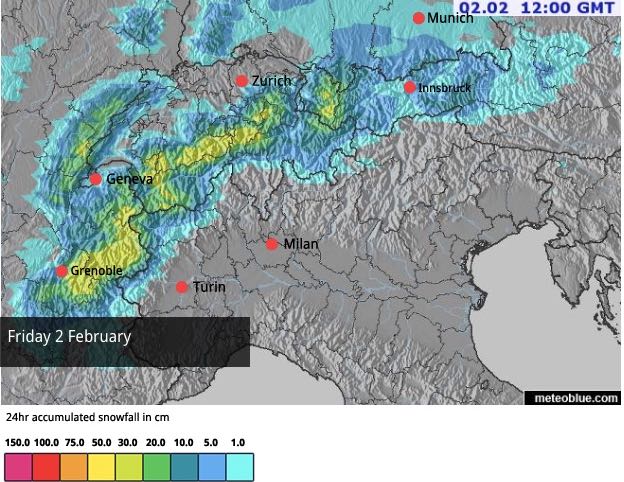
Crikey snowfiends, have you seen today’s Snow Forecast for the Alps?
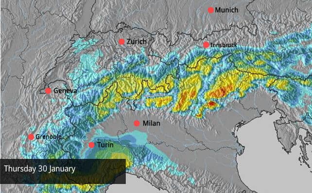
As you can see, heavy snow is falling – again – in the southern half of the Alps, repeating a pattern we’ve seen many times this winter. If the forecast is correct, most resorts in the Italian Dolomites will see half a metre of snow, and a few isolated spots nearly double that. There will also be heavy snow in southern Switzerland, and the southern French Alps.
Here’s a taste of what’s been happening, courtesy of the morning webcams.
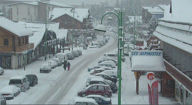
Pictured below the centre of Les Deux Alpes, south of Grenoble. Here the local snow report records 30-160cm of settled snow, depending on altitude.
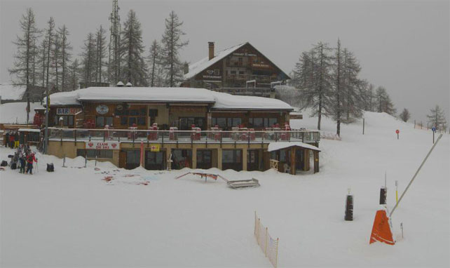
Pictured below is Serre Chevalier, where the snow is currently 95-200cm deep, on-piste, depending on altitude.
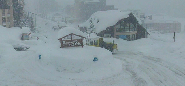
Meanwhile, this is little Isola 2000, hidden away in the mountains north of Nice. Here, the settled snow is 185cm deep in town, and 255cm higher up.
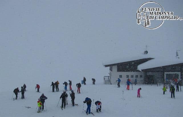
Pictured below is Madonna di Campiglio in the Brenta Dolomites, where the snow is currently 170-200cm deep.
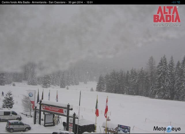
And this is San Cassiano, further east, where the snow is 120-230cm deep.
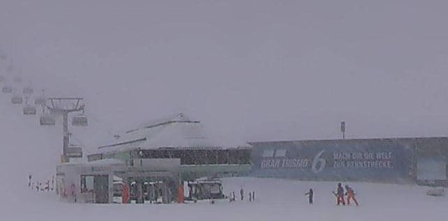
Finally, here’s Obergurgl in Austria, which is hard up against the Italian border and clearly experiencing similar conditions as the southern Alps. Here, the settled snowpack is 65-170cm deep.
Needless to see, the avalanche risk is going to be high after such a big storm. If you’re tempted, check the local avalanche warnings, hire a local guide and make sure you’re properly equipped.
Further north in the Alps, conditions improved considerably in the wake of fresh snow at the weekend, and in the immediate aftermath there was glorious sunshine, too. Even down to lying-lowing resorts, at 1000m, there was some cracking skiing to be had, on soft, cold, grippy snow.
Here’s some video of conditions in St Anton, in the Austrian Arlberg, yesterday. The resort had around 40cm of fresh snow last weekend, and reports settled cover 50-125cm deep.
Conditions are less amazing now, thanks to flat grey skies and strong southerly winds, which are a by-product of the blizzards in the south. However, it’s not turning too mild, and Meteo Chamonix in France reckons the freezing point won’t rise above 1200m in the short term. Skiers above that level should still find a good, grippy skiing surface on-piste.
At the weekend, the weather will change again. Below is the Snow Forecast for the Alps on Sunday – when many resorts in France and western Switzerland should see 20cm of fresh snow.
Fresh snow in western US
It’s been snowing in the resorts of the western US too.
Most significantly, the resorts of northern California have seen snow, with Heavenly at Lake Tahoe notching up 18cm overnight – a big relief after a such a dry first half of the season. Further east, Snowbird in Utah reported 25cm of fresh snow this morning, and the Canyons 18cm, while in Colorado Breckenridge has 15cm of new snow, and Steamboat 20cm.
In Wyoming, Jackson Hole reported nearly 30cm of new snow as the lifts opened.
There’s more snow to come before the storm blows itself out on Saturday – and there are signs more could come to the American Rockies next Tuesday, too.
Meanwhile, in Rosa Khutor…
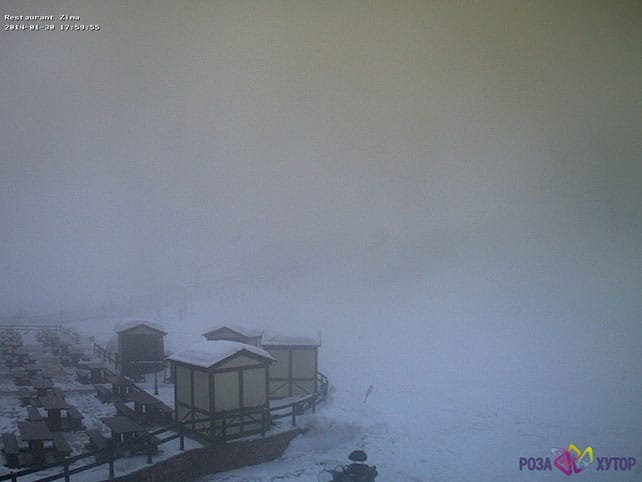
Rosa Khutor will be hosting all the Alpine Skiing disciplines at the Winter Olympics, and currently reports 75-270cm of settled snow.
| France: see the main report. There was fresh snow in the north at the weekend. Now there’s heavy snow in the south. More of the white stuff is expected in the north again at the weekend. The only drawback is that sunshine will be in short supply until the skies clear on Monday. Currently, Val d’Isere reports 89-153cm of settled snow, Meribel 90-124, and Serre Chevalier 100-205cm. | |
| Switzerland: as in France, conditions in the north improved in the wake of the weekend snow, and now the resorts close to the Italian border, such as St Moritz, are getting walloped. Currently, in the west, Verbier reports cover 35-131cm deep. In the north, Laax has snow 20-160cm deep. In St Moritz in the east, the snow is 111-155cm deep on the pistes. | |
| Austria: the fresh snow at the weekend brought a big improvement to conditions in the resorts north of Innsbruck, although it looks like they’ll miss out on most of the snowfall in both the southern and north-western Alps over the next five days. Currently, the Skiwelt reports snow 50-80cm deep across the ski area. Close to the Italian border, high-altitude Obergurl has snow 65-170cm deep, and is getting plenty more of the white stuff today. In the Arlberg St Anton has 50-125cm of settled cover. | |
| Italy: the southern Alps are getting another dump, and nearly all Italian resorts have extraordinary amounts of snow by the standards of a normal season. Currently, above the Aosta Valley, Cervinia has 145-300cm of snow on its slopes. In the Dolomites, Canazei reports 55-210cm. Those figures should be significantly higher once this latest storm has passed. | |
| Andorra: the Pyrenees were hoping for heavy snow at the end of last week, but in the end the weather didn’t serve more than a few cm. Currently, Soldeu and Pas de la Casa in Grandvalira report 90-200cm of settled snow, and there should be more snow at the weekend. | |
| Western USA: see our main report. In the short term at least, the snow drought in California is over. Let’s hope the resorts there get plenty of the white stuff in the second half of the season to compensate. Meanwhile, in the Rockies, resorts are looking forward to a day or two of moderate to heavy snow. Currently, Breckenridge has 168cm packed down, mid-mountain, Snowbird has 166cm, and Jackson Hole 150cm. | |
| Western Canada: Whistler’s so-so season continues, with 2cm of snow in the last week and only 308cm so far this winter, which is not much by normal standards. Currently, the mid-mountain snowpack is 130cm deep. Inland, Sun Peaks reports 8cm of snow in the last 24hrs, and 140cm of snow packed down on its higher runs. Lake Louise in Banff National Park reports 10cm of fresh snow overnight and a mid-mountain snowpack of 138cm . |


What a winter they’re having in the Italian Alps! https://t.co/9fy2fpLdLF https://t.co/KbuGJ5lRww
“@welove2ski: What a winter they’re having in the Italian Alps! https://t.co/Dqo9msePhz https://t.co/kU0FVCpAR0” Bring on Sunday!!
Top story: Snow Report, January 30 | Welove2ski https://t.co/7aarXuwbKM, see more https://t.co/NJkZiaWIgw
Such a shame you don’t include any Andorran resorts in any of your info –
Soldeu Ski School is regularly voted ‘best English speaking ski school in the world’ by Neilson clients.
Snow levels currently 90cm – 200cm at the top, but less avalanche risk than currently in the Alps – plus a mere 206km of piste to enjoy ….
Maybe you need to check it out?
We do mention Andorra, Isobel! It’s included every week in our snow reports. And here are the details we have on ski schools there: https://www.welove2ski.com/grandvalira-soldeu/where-to-learn