


Snow Report – Monday 07 April 2025
Wear Sunscreen
In today’s snow report, we’re tracking conditions across Europe, North America, and Asia. The Alps are basking in sunshine, while fresh snow has landed in parts of the U.S. and Japan, setting things up nicely for the week ahead.
Wondering where the next big dump is expected? We’ve pulled together the latest forecasts and best bets for chasing powder.
Let’s get into it.
Snow Report
Our ‘on the snow’ reporters have been enjoying great Spring conditions.
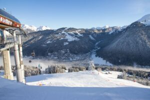
Les Crosets Snow Report, Switzerland
Dave Burrows sent us this report from Les Crosets, Switzerland where he enjoyed wall to wall sunshine and the full gamut of Spring snow conditions.
Click here to book lessons with Snowpros ski school in Switzerland.
Arizona Snowbowl Snow Report, Arizona, USA
Deep powder in the trees at Arizona Snowbowl
View this post on Instagram
Niseko Resort Area Snow Report, Hokkaido, Japan
Epic April turns on the dormant volcano Mt Yotei which dominates the Niseko Resort Area skyline.
View this post on Instagram
World Snow Forecast For The Next 3-4 Days

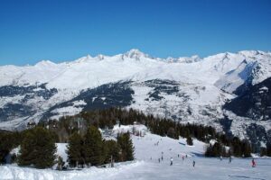
It’s sun, sun, and more sun for the first week of the Easter Holidays in Austria, France, Italy and Switzerland.
The freezing level will range between 2,300m and 2,500m with freeze thaw conditions below that level and great Spring skiing in the alpine.
Don’t forget to plaster on the sunscreen. It’s google tan season.

It’s a similar situation in Andorra and the French & Spanish Pyrenees with the chance of 5-10cm up high on Wednesday evening.
It will be much colder in Central and Eastern Europe with below freezing temperatures across much of the region and the chance of 5-10cm of new snow.
It will be a snowy start to the week at the Georgian and Turkish resorts with 10-15cm of new snow forecast. Gudauri, Georgia is expecting 40-45cm and Tetnuldi, Georgia could see 70-75cm.
Temperatures will hover around freezing in the Nordic Countries of Finland, Norway and Sweden with freeze thaw conditions and 5-10cm of snowfall on the highest peaks. Narvik, Norway continues to catch the storms with 60-65cm of new snow expected.

The Canadian resorts of Alberta and British Columbia will see below freezing temperatures and 5-10cm of new snow. Whitewater and Whistler Blackcomb could see 25-30cm of new snow.
The temperatures will drop on the East Coast of Canada with 10-15cm of new snow forecast for Tremblant, Quebec.
April has started cold and snowy at the Western US resorts but the next 3-4 days will see a warm spell move in to the region bringing sunshine and freeze thaw conditions.
The West Coast resorts of California will see clear skies, sunshine, and above freezing temperatures.
The Oregon, Washington and Alaska resorts will see 10-15cm through Thursday. Mt Hood, Oregon; Crystal Mountain, Washington; and Alyeska, Alaska are forecast to receive 25-35cm.
The East Coast of the United States will see below freezing temperatures and 5-10cm of new snow.
Spring has sprung on Japan’s main island of Honshu bringing sunshine, freeze thaw conditions, and light rain below mid-mountain but 5-10cm of new snow above.
It’s a calm start to the week further North on the island of Hokkaido with clear skies and sunshine.
Where To Ski
There will be very good Spring skiing across the Alps but head to north facing slopes above 2,500m for the best conditions.
Gudauri and Tetnuldi, Georgia are the best choices out East with snow forecast through to mid-April.
As has been the case for most of the Winter, Narvik is the go to destination up North.
Further afield a Spring trip to British Columbia, Canada and the Pacific Northwest resorts of Oregon and Washington are worth the travel time.

Add Comment