0
0
Share with your friends


Submit
  • Home
  • About
  • Advertising
  • Privacy
  • Property
  • Contact
  • Sitemap

Logo

Navigation
  • Ski Resorts
  • Where to Ski
  • How to Ski
  • Snow
    • Snow Report
  • Gear
    • Ski Clothing
    • Ski Equipment
  • Family Skiing
  • Ski Holidays
  • Deals
  • Summer

Stormy Weather Ahead!

By Peter Hardy | on January 15, 2018 | 0 Comment
Snow Report
Stormy Weather Coming | Welove2ski

Val d’Isere at the weekend. Photo: (c) Welove2ski.

Hurry up and clear that roof, because tomorrow you’re going to have to start all over again!

Just when pisteurs and snowplough drivers have managed to catch up on their sleep after round-the-clock shifts to keep runs and streets open and safe, Storm Evi is now making landfall in France – and it looks like it’s about to happen all over again.

Evi is forecast to dump another 50-150cm over the next few days on resorts all across the northern Alps, swooping in from the Atlantic to buffet the mountain range with heavy snow and high winds, making the snowpack dangerously unstable once more. The avalanche danger has dropped from a maximum five to three, or even two in some places. However, it’s set to soar again from tomorrow.

Throughout the remainder of this week a sequence of cold and warm fronts should produce an unsavoury combination of yoyo-ing temperatures and 100kph winds, accompanied by heavy snow at altitude and rain lower down. The storm is likely to cause the temporary closure of lift systems and potentially create havoc for holidaymakers departing or arriving in resorts. The northern French Alps, along with western Switzerland, will bear the brunt on the storm – but fresh snow cover should be widespread.

The return of the tempest comes after a brief and glorious lull in the bad weather. Blue skies over the weekend saw the best ski conditions of the winter in resorts such as Val d’Isere, Tignes, and Sestriere/Sauze d’Oulx after they were hammered with two metres of snow in as many days by a local weather phenomenon. Snow swept up from the Mediterranean in what is called the Retour d’Est, bringing the biggest January fall in at least 30 years to the Haute Maurienne and Haute Tarentaise valleys.

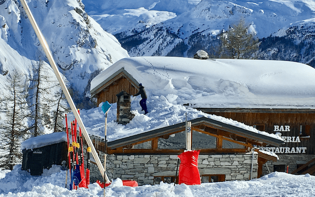
In Val d’Isere owners are struggling to clear overloaded roofs, 200cm banks line the streets, and snowplough workers are left scratching their heads, wondering just where to park the next lot…

Share this story:
  • tweet

Tags: Snow Report

Recent Posts

  • Six Reasons We Love Going to St Anton by Train

    February 1, 2023 - 0 Comment
  • 7 of the Best Wines to Sip on A Dolomites Ski Trip

    January 24, 2023 - 1 Comment
  • 5 Ways to Make Your Tirolean Ski Holiday More Sustainable

    January 23, 2023 - 0 Comment

Related Posts

  • Fresh Snow in Italy – and Lots More to Come in the North

    February 15, 2022 - 0 Comment
  • Half-Term Snow in Both the Southern and Northern Alps

    February 11, 2022 - 2 Comments
  • Here Comes Another Snowstorm

    February 5, 2022 - 0 Comment

Author Description

Peter Hardy

An editor at Welove2ski, Peter is also writes about skiing for The Daily Telegraph and Daily Mail. He first put on skis as a child on a family holiday, and has since been to some 500 resorts around the world.

No Responses to “Stormy Weather Ahead!”

Leave a Reply Cancel reply

Free Updates

Join 16,000 clever people who get the latest Welove2ski content delivered to their inbox

RSSSubscribe 15199 Followers 10135 Fans

The Loveometer

Zermatt: Cool Chalets, Certain Snow and The Majestic Matterhorn
100 %
Tweenager Tips: How to Enjoy Ski Holidays with Older Kids
98 %
How to Go Green On Your Ski Holiday
98 %
St Anton, Austria: Wild Nights, Steep Pistes and Challenging Backcountry
97 %
Weird and Wonderful Ski Fads and Fashions
94 %
  • Home
  • About
  • Advertising
  • Privacy
  • Property
  • Contact
  • Sitemap
© 2020. All Rights Reserved. Created with love by WL2S