


Austria has got its snow!
Three days of stormy weather has brought up to half a metre of the white stuff to the resorts north of Innsbruck, and dramatically improved skiing conditions there. After a threadbare start to the season, it’s a huge relief.
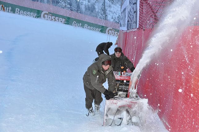
But it didn’t help much with the preparations for the most famous ski race in the World Cup calendar: the Hahnenkamm, which took place this weekend in Kitzbuhel. Heavy snow is the last thing the Kitzbuhel Ski Club needs as it prepares the course: and it’s a nightmare for the racers too. Still, they managed to complete a full programme of racing: and top honours was taken by Austrian, too – Hannes Reichelt. Cue wild rejoicing across the country, because for many Austrians the Hahnenkamm is far more important than the Olympics.

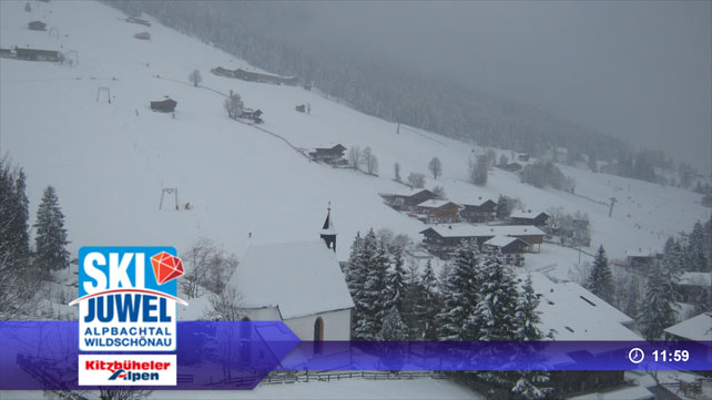
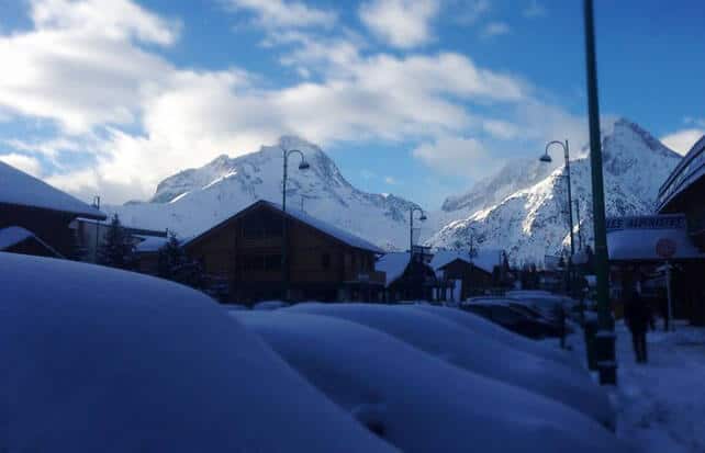
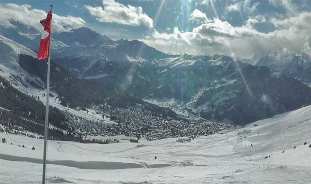
Pictured below is the fresh snow yesterday in Alpbach – part of the Ski Juwel ski area.
And it’s still snowing there today.
Here’s today’s snow forecast for the Alps to show you how much is expected before this welcome blast of winter blows itself out.
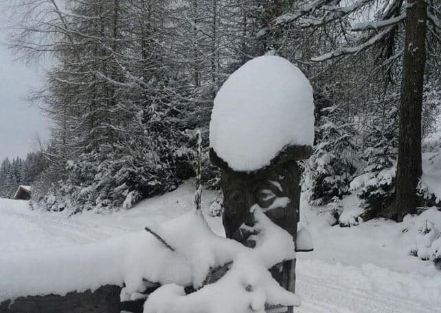
In fact, there’s been fresh snow right across the northern half of the Alps, and many resorts are reporting 25cm of fresh overnight, to add to the snow that fell on Friday and Saturday. It’s been carried on a cold northerly wind too: so it’s light, dry and soft. The pistes have been considerably improved as a result, and the powder will look mighty tempting to off-pisters today as the skies clear.
However, great caution is needed if you’re planning to ski off-piste. Thanks to the stormy conditions that accompanied the snow, there are lots of wind-packed slabs about, which have bonded very poorly with the old snowpack underneath. Don’t go off-piste without a guide, make sure you’re properly equipped, and always, always err on the side of caution.
Now, a change in the weather is expected
Sadly, a change in the weather is now on the cards: because on Wednesday the wind is going to switch into the south, and a weak Foehn wind will blow. The freezing point is going to rise too – though it won’t be too mild in the short term. In France, Meteo Chamonix thinks the 0C mark will hit 1600m on Wednesday.
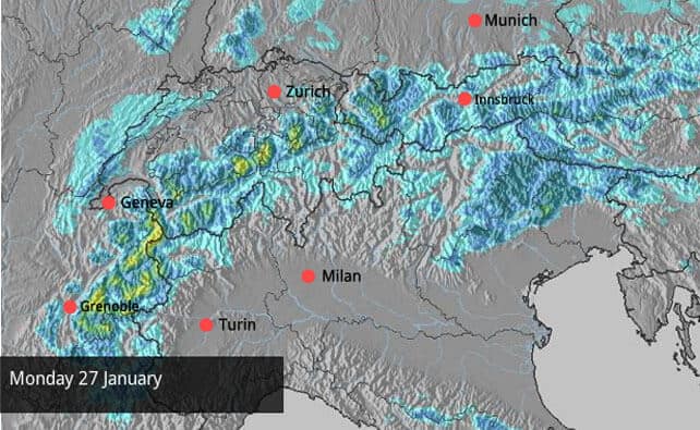
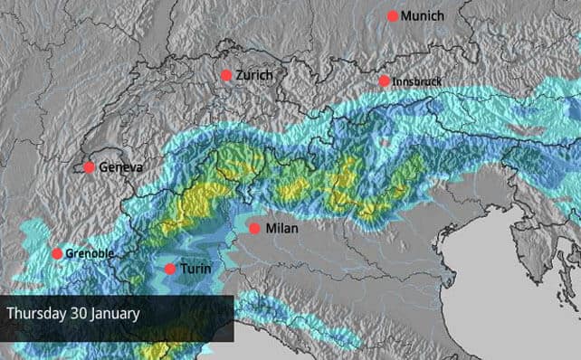
There’s going to be heavy snow across the Italian side of the Alps too. Here’s the snow forecast for Thursday – showing a return to the kind of storm which has dominated the Alpine weather so far this winter.
So, bearing in mind that caveat, here’s how it’s looking across the Alps as a result of the wintry blast, starting with a lovely shot from Les Deux Alpes, taken this morning.
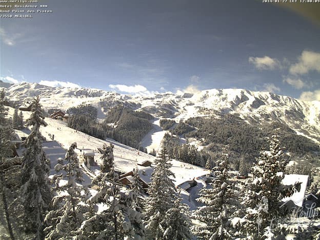
Below, is Meribel, looking gorgeous in the sunshine, with 20cm of new snow today. Total snow depths are 90-125cm, depending on altitude.
This is La Clusaz. Total snow depths here are 48-130cm.
Below, is Verbier, which reports 15-20cm of fresh snow overnight and total snow depths of 48-150cm.
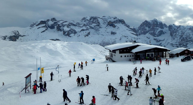
Meanwhile, pictured below, is Madonna di Campiglio in Italy’s Brenta Dolomites. There hasn’t been any new snow here for a week, but after a cracking start to January, the snow pack is still 180-240cm deep. More snow is expected here on Thursday.
In North America, the weather changes on Wednesday
Today, there’s a little snow blowing around Wyoming and northern Colorado, in the American Rockies; enough to bring 2cm of snow to Breckenridge, and maybe double that in Jackson Hole. However, the big change is coming on Wednesday, when the ridge of high pressure that has dominated the weather over the western seaboard for weeks finally breaks down. As a result, snow is expected across much of the Pacific Northwest, the Sierra Nevada in California, and the American Rockies. It’ll become milder too. Californian skiers in particular will heave a huge sigh of relief. For them, the exceptionally dry start to winter has been tough going.
| France: there’s fresh snow across much of the French Alps today, in the wake of the weekend snowstorms. Off-piste, the risk is considerable – generally, 3/5, but the pistes are in great shape, and there’s been a big improvement in conditions in the lower resorts. However, it will warm up later in the week once the Foehn starts to blow. Currently, Val d’Isere reports 90-160cm of settled snow and Serre Chevalier 95-200cm. Serre Chevalier is one of those more southern French resorts which should see heavy snow on Wednesday and Thursday. | |
| Switzerland: as in France, conditions have improved in the wake of the recent snow, and most of the central and northern resorts have received an 18-30cm top-up. In the west, Verbier currently reports cover 48-150cm deep. In the north, Laax has snow 20-140cm deep. In St Moritz in the east, it’s about 146cm deep, mid-mountain. | |
| Austria: see our main report. Conditions have improved dramatically in the resorts north of Innsbruck, although the snowpack is still a lot thinner than elsewhere in the Alps. Currently, the Skiwelt reports snow 50-80cm deep across the ski area, and proper, wintry conditions at village level. Close to the Italian border, high-altitude Obergurl has snow 71-179cm deep, while in the Arlberg (St Anton) has 55-130cm. | |
| Italy: the early weeks of 2014 were marked by moderate to heavy accumulations of snow across the Italian Alps, so they weren’t too bothered by the lack of fresh snow over the weekend. And besides, another dump is on the way in the middle of the week. Currently, above the Aosta Valley, Cervinia has 145-300cm of snow on its slopes. In the Dolomites, Canazei reports 50-195cm. | |
| Andorra: the Pyrenees were hoping for heavy snow at the end of last week, but in the end the weather didn’t serve more than a few cm. However, the next couple of days are looking promising. Currently, Soldeu and Pas de la Casa in Grandvalira report 90-180cm of settled snow, and nearby Vallnord has even more at Arcalis. | |
| Western USA: see our main report. After a cracking start to 2014 in the American Rockies, the weather has been mostly dry for more than a week. However, a big change in the weather is expected on Wednesday, when mild, wet weather moves in from the Atlantic, bringing wet and heavy snow to many areas. Currently, Breckenridge has 140cm packed down, mid-mountain, Snowbird has 145cm, and Jackson Hole 120cm. | |
| Western Canada: Whistler will benefit from the change in the weather mid-week along the Pacific coast. Light snow is expected from the middle of the week – the first the resort has seen for some time. Currently, the mid-mountain snowpack is 130cm deep. Inland, Sun Peaks reports 141cm of snow packed down on its higher runs, and Lake Louise in Banff National Park has up to 138cm. |


At last: the north Alps have gone all wintry! https://t.co/oJbMTZdYNs
Welcome news in Austria….Snow Report, January 27 | Welove2ski https://t.co/BXcK5RGWbz via @welove2ski