


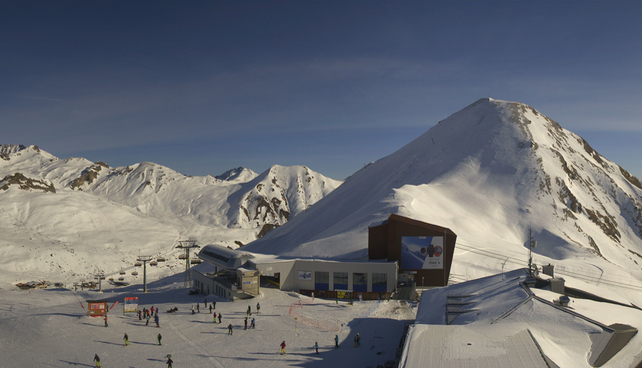
Check out the shot of Ischgl, in the Tirol, above. It was taken this morning, when the last of the sunshine was gracing the western end of Austria.
We won’t be seeing it again for a while in the northern Alps: because the high pressure that’s dominated the region in recent weeks has retreated further south than expected. As result, a big Atlantic storm is going to sweep across the mountains, and dump significant amounts of snow.
This is Meteoblue’s 24 hour snow forecast to 1am on Wednesday morning. As you can see, the northern half of the French Alps will be the sweet spot at the start of the storm. 50cm is expected to fall there during the course of Tuesday. As much as 70cm could fall by Wednesday night.
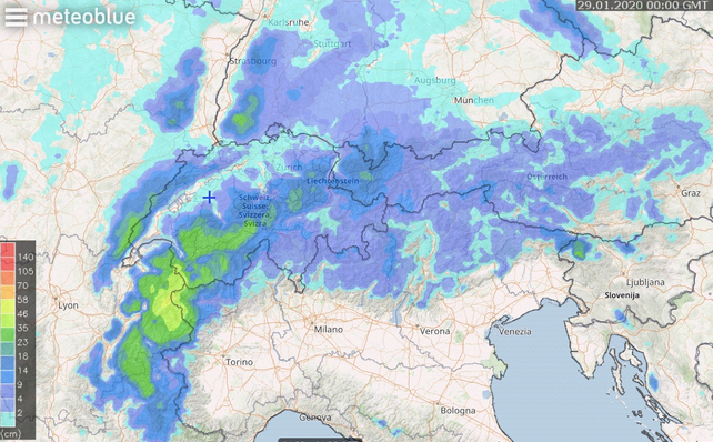
The snow will spread eastwards as the week unfolds and parts of Switzerland, as well as the Austrian Arlberg, should see heavy snow too. However, accumulations are unlikely to match the final figures in the west.
Expect blizzard conditions on the higher slopes, and a sudden jump in the avalanche risk as wind-slabs form on top of a hard layer of existing snow. Great caution will be needed if you’re tempted to venture off-piste. You might want to avoid exposed pistes during the storm too – until skies have cleared, the snow has begun to settle and resorts have completed their programmes of pre-emptive blasting.
Still, despite the avalanche risk, the new snow will be very welcome. We’ve had a month now of almost continuous sunshine in the Alps, and the slopes have been hard for weeks (except during the snowy weekend of January 18-19). Injuries have been frequent on the hard-packed pistes. It’ll be a relief to have something softer to ski on.
However, you will have to aim fairly high to find those benign, wintry conditions. Because phase two of the upcoming storm cycle is going to be significantly warmer than the phase one.
On Tuesday night, for example, the snow will be settling well below 1000m. On Thursday, by contrast, it’ll be raining up to 2000m. So – as was so often the case in December – a welcome delivery of snow in the lower resorts will followed almost immediately by an annoying thaw. Aim high if you want to ski soft, chalky pistes (or powder) for as long as possible.
By the way, have you seen the second round of fabulous ski drills from St Anton – as demonstrated by the most rubber-jointed skier I think I’ve ever seen…
https://www.facebook.com/Stanton.Arlberg/videos/2565406473781613/


I was waiting for his knee to pop out when he did the single leg exercise.