


And so it begins. What looks like the storm of the season arrived last night and began dropping what should be at least a metre of snow over the western Alps. In some places, the final total might even be double that.
This morning, most resorts in France and western Switzerland were reporting 10-15cm of fresh overnight, and it’s been falling ever since: sometimes heavily, at others less so.
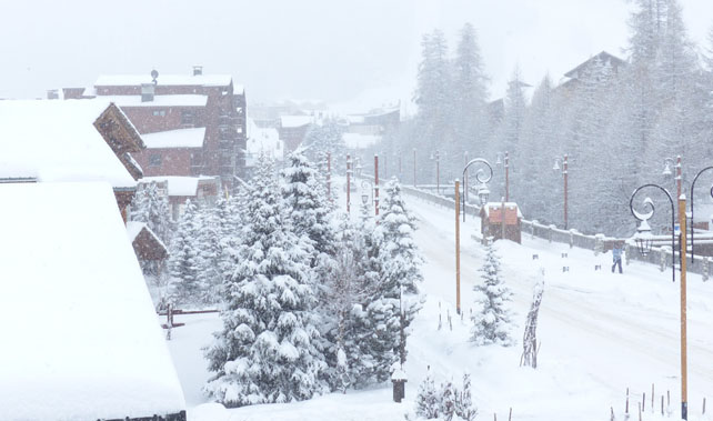
Here’s how Val d’Isere was looking this morning, courtesy of John Yates-Smith of YSE.
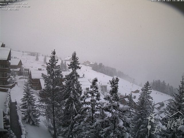
Pictured below this was the scene in Meribel this afternoon.
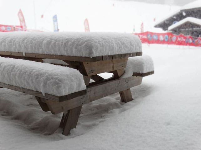
Meanwhile, Les Gets posted this photo on its Facebook page, and reckons 30cm of snow has fallen so far.
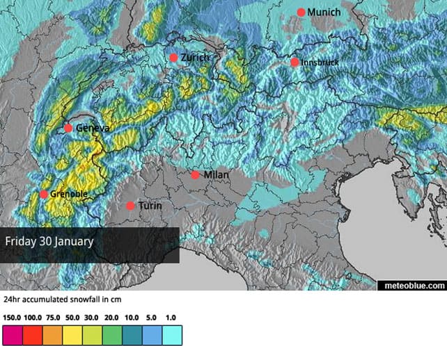
This evening, it’s set to get even snowier – and the storm will extend its reach, over into Austria and the south-eastern Alps for a time tomorrow. Our latest snow forecast for the Alps for January 30 gives you an idea of its extent.
It’s now clear the eastern Alps won’t get as much snow as the west, although conditions are already excellent, thanks to several top-ups in recent days, and a good 30cm dump on Tuesday. I’m writing this in Zell am See in Austria, and yesterday on the Kitzsteinhorn glacier there was at least a foot of light, dry powder on every slope, off-piste, with half a metre lurking in the gullies. It felt almost bottomless. Here’s my guide Wolgang Jernej of the Alpine Skischule making the most of the near-perfect conditions.
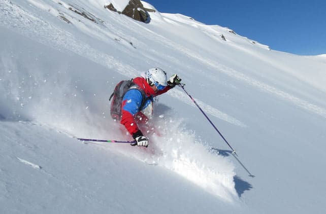
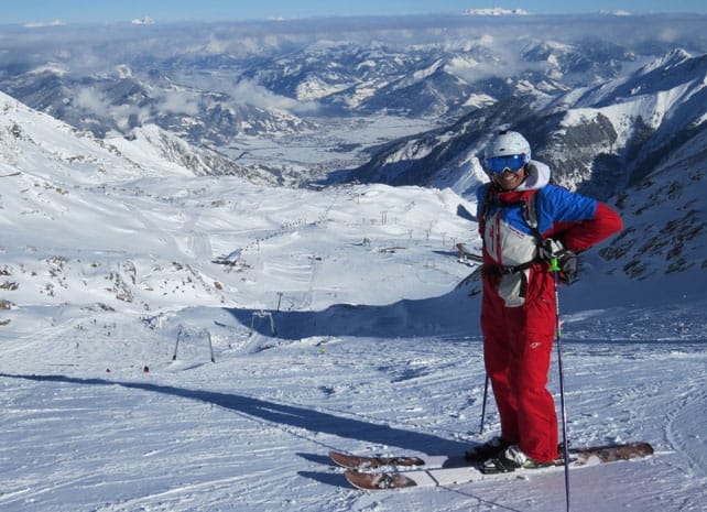
It’s not just the glacier that’s got snow: this shot gives you an idea of the way the white stuff goes all the way down to the valley floor.
When the skies do eventually clear, and all the fresh snow is groomed into the pistes, conditions are going to be superb almost everywhere in the northern Alps, and especially in France and western Switzerland. However, the sheer quantity of snow expected, and the duration of the storm, is also causing concern. This afternoon, for example, Le Dauphiné Libéré reported that the Mayor of Samoens had held a meeting for everyone concerned with public safety to go over plans in case the snow becomes unmanageable. In Chamonix, they’ve been urging skiers and snowboarders to be ultra-cautious when it comes to venturing off-piste. I don’t blame them. Until the new snow settles, conditions are going to be dangerous.
| France: see our main report. The French Alps look set to be walloped by snow over the next five or six days. There’s no sign of a let-up till next Wednesday. The avalanche risk will be going through the roof as a result, and the pistes are likely to be pretty lumpy each day as the new snow gets pushed around by skiers. Still, once skies clear, there’s going to be superb skiing everywhere, in the short term at least. Currently in high-altitude Tignes there’s 65-128cm of cover, on-piste, and the snow is fresh and soft. Meanwhile, in Serre Chevalier, there’s 20-130cm of cover, on-piste. | |
| Switzerland: in western Switzerland, the situation is very similar to France. Heavy snow is expected, and the avalanche risk will be very high for the next few days. Further east, there’ll be snow too, although it’ll generally be much lighter. Currently Verbier, in the west, has 40-120cm of cover on its pistes, Laax in the east reports snow depths of 50-270cm, and St Moritz in the south has 50-135cm. | |
| Austria: Austrian resorts have had a good week: many picked up 10cm on Sunday night, another 30cm on Tuesday and 10cm early on Thursday morning. In the Arlberg, they had even more than that. There will be light to moderate snow over the coming five days too – nothing like the same quantity as will fall in France, but still enough to keep the pistes in great shape. Currently, in the Arlberg, Lech reports cover 100-160cm deep, and in the northern Tirol the Skiwelt has 60-80cm on its pistes. Meanwhile, in the east, Schladming has 70-115cm of settled snow on its pistes. | |
| Italy: Italy will miss out on most of the snow that’s due to fall over the next five or six days, although it won’t be completely dry either. The Aosta Valley in particular will see light to moderate snowfall on an almost daily basis will the blizzards blow further north. Meanwhile, in the central Italian resorts of Madesimo and Livigno the cover is still very deep in the wake of the big dump of January 18. In Madesimo, for example, there’s 170cm on the lower slopes and over four metres higher up. Meanwhile, above the Aosta Valley, Cervinia reports 20cm of fresh snow today and cover that’s 140cm deep, mid-mountain. | |
| Andorra: in Andorra, the Grandvalira ski area reports a respectable 50-110cm of cover on its pistes, and is looking forward to heavy snow from tonight onwards. In fact, it may be heavier here than in the Alps. | |
| Western USA: it’s been a disappointing week for the many powderhounds of the western US. Temperatures have generally been very mild for late January and there’s not been much in the way of fresh snow. Southern Colorado should see wet snow of over the next two days, with rain up to 2,500m. There may also be a few flakes in the resorts of the northern half of the state next week, but it looks as though Wyoming and Montana will do better. As a result, Jackson Hole could be the best place to ski next week. Currently, its mid-mountain snowpack is 172cm deep. Meanwhile, in Utah, Snowbird in Utah has 165cm of mid-mountain cover, and reports a light dusting of fresh snow today. In Vail, the settled snowpack is 99cm deep, mid-mountain. | |
| Western Canada: Whistler’s so-so season continues. It hasn’t snowed for over a week, and the mid-mountain snowpack is down to 122cm. Conditions are described as “hard-packed”. Inland, in Banff National Park, temperatures are dropping back after a mild week. At Lake Louise, tomorrow’s high should be -6C and then -10C on Saturday. Currently, the snowpack is 115cm deep, mid-mountain. |


Add Comment