


It’s been a busy week of weather in the northern Alps, and there was more snow across the region yesterday. It’s still falling today in eastern Switzerland and Austria – accompanied by high winds. It’s windy in the west, too.
The current wintry conditions will be short-lived. High pressure is settling over the region and a dose of sunny spring weather is just around the corner.
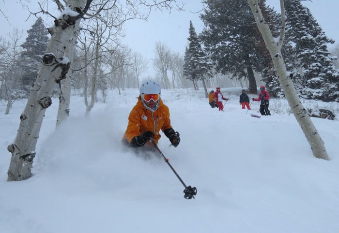
In the Rockies, the resorts of Utah and Colorado have just been treated to another powder day.
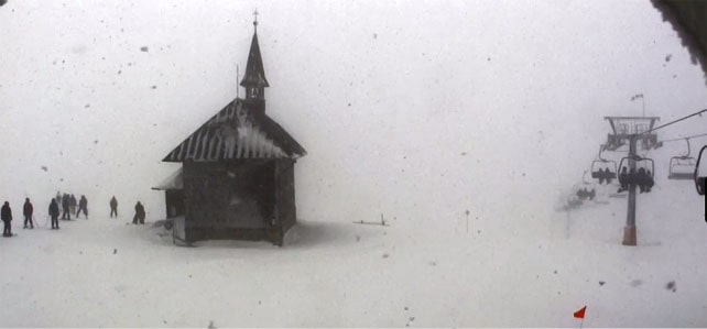
Here’s a taste of today’s weather in the northern Alps. Pictured below was the Schmittenhohe, above Zell am See, this morning.
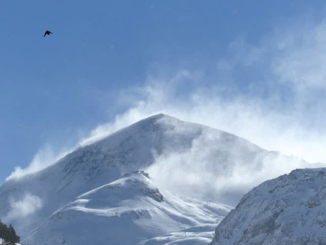
Meanwhile, pictured below, is how it was looking in Val d’Isere in France this morning: with sun out already and strong winds scouring the high peaks and ridges. “-18º up high today, with 150kph winds! This chough was loving it, doing 360s and tail grabs like a park rat,” says John Yates-Smith, of YSE, who took the picture.
And here’s the snow forecast for today.
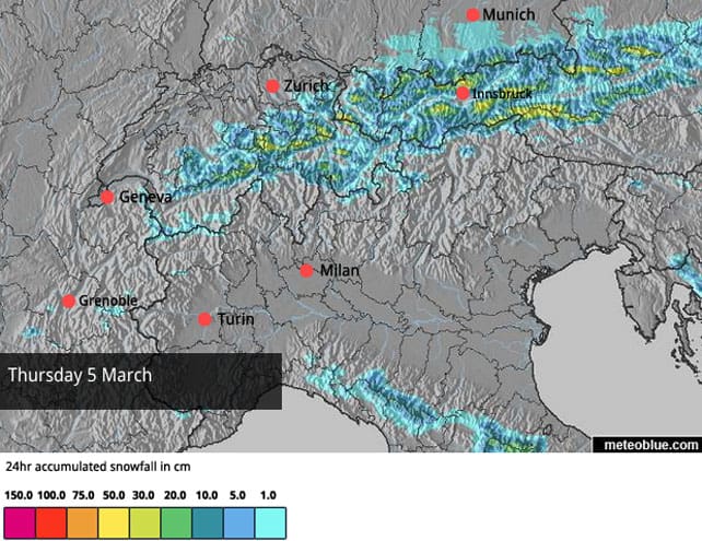
In Austria 10-20cm of fresh snow is expected in most resorts, to add to the 10-20cm that fell yesterday. The resorts in the north will get the lion’s share. Those lining the Italian border will see rather less.
In France and western Switzerland, the skies have already cleared, and there will be some lovely skiing on the 10-20cm of new snow that fell here yesterday. Off-piste, however, the high winds are creating unstable, wind-drifted slabs of snow and the avalanche risk is considerable. Proper powder is in short supply.
Conditions in Austria will be very similar tomorrow once the clouds lift.
Skiers will need to be quick to get the best from the current wintry conditions, because a settled spell of mild spring weather is just around the corner. In France, Meteo Chamonix expects the freezing point to rise to 1600m tomorrow and 2500m on Saturday. It’ll be cooler in the east for a time, but on Sunday the freezing point Austria will hit 2600m. Slopes below that level will be going a daily melt-freeze cycle, and spring-skiing tactics will be essential to get the best from the skiing day. (Check out Vincent Lalanne’s feature on how to find the best snow in ski resort for more on that.)
The mild spell looks set to last until the middle of next week at least.
Meanwhile in the Rockies…
There’s been more snow in the Colorado and Utah Rockies. I’m currently out in the Canyons, near Salt Lake City, and on Tuesday we had about a foot of light, dry Utah powder to play in.
This was Brenda Lytle, making the most of it…
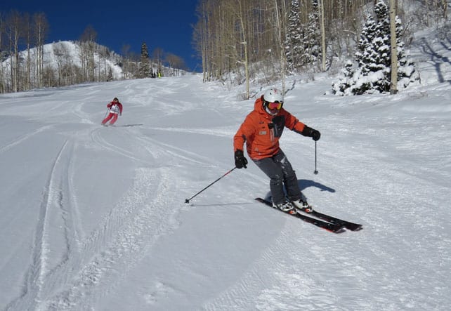
Then, yesterday, the sun came out. Most of the powder was already skied out, but the crud was generally light and soft and the pistes were absolutely gorgeous.
Beaver Creek in Colorado reported 30cm of fresh snow from the same storm.
Colorado in particular has had a fabulous fortnight of snow and conditions are superb almost everywhere. However, here too there’s going to be a mild and sunny spell for about a week now.
| France: there have been several top-ups of snow this week across the northern half of the French Alps, but not so much in the resorts south of Grenoble. Below about 2000m the underlayer is quite icy, but there’s been enough fresh snow in the northern resorts to cover it. Further south, it’s more of an issue. Today it’s generally cold and windy, but the wind will drop tomorrow and temperatures will jump. Expect spring conditions at the weekend. South of Grenoble, Serre Chevalier reports 35-150cm of cover on its pistes. Meanwhile, in high-altitude Val Thorens in the Three Valleys, there’s 145-230cm packed down on the pistes. High-altitude resorts such as Val Thorens, Val d’Isere and Tignes will have the best conditions during the coming thaw. | |
| Switzerland: there’s been a decent top-up of snow across the Swiss Alps this week, with some areas clocking up more than 40cm of fresh in the last three days. Here too, a spell of spring weather is just around the corner so aim high for the best conditions. Currently Verbier reports 15cm of fresh snow at the top of the resort, and has 60-235cm of cover on its pistes, Laax in the east reports snow depths of 40-330cm, and St Moritz in the south has 65-154cm. | |
| Austria: it’s still snowing in Austria, and conditions on-piste are likely to be gorgeous once the wind drops and the skies clear. However, here too, temperatures are set to rise and the best skiing is going to be in the high-altitude resorts come Sunday. In the Arlberg, Lech currently has 115-230cm of cover, on piste, and in the northern Tirol the Skiwelt has 55-75cm. Meanwhile, in the east, Schladming reports 80-140cm of cover, on-piste. | |
| Italy: in Italy it’s been mostly dry this week. Areas close to the French, Swiss and Austrian borders have however had the occasional top-up. Cervinia had 20cm on the top half of its slopes on Sunday, and reports cover 50-290cm deep, on-piste. There was up to 10cm in the Dolomites yesterday, as well, and Canazei has 40-130cm of cover on its pistes. But generally the resorts here have missed out on the snowfall enjoyed by the north this week. | |
| Andorra: the Pyrenees have enjoyed a short wintry spell this week, although here too it will be short-lived and spring weather is on the way. In the Grandvalira ski area, snow depths range from 140-210cm, on-piste. | |
| Western USA: there’s been fresh snow in the Rockies – and in California too. Colorado and Utah have some of the best conditions at the moment. Currently, in Colorado, Vail, reports that its mid-mountain snowpack is currently 157cm deep, and in Telluride it’s 180cm. In Utah, the Canyons reports 142cm of settled snow, mid-mountain. | |
| Western Canada: snow-wise, Whistler’s season is stubbornly refusing to take flight, with just a sprinkling of snow recorded in the last week, and surface conditions hard-packed. Temperatures are set to rise this weekend, too. Inland, in Banff National Park, Lake Louise is expecting a high of +1C, and reports a mid-mountain snowpack 120cm deep. |


Hi – Got a long range forecast for 3 valleys 14th March onward