


Spring is going to be distinctly less spring-y in the Alps for the next few days.
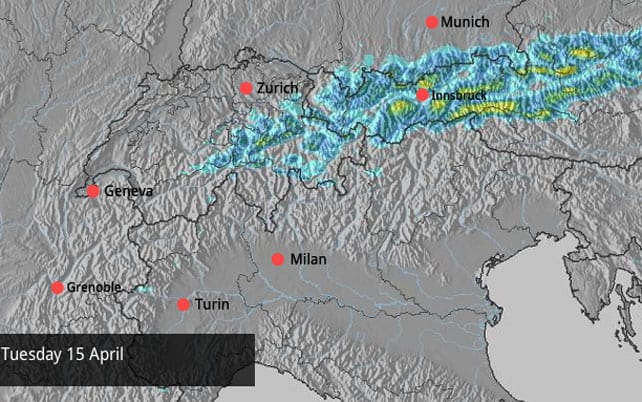
As regular followers of our Snow Report will know, the weather has – for the most part – been magnificent, sunny, and very warm in the Alps since early March. But the high pressure that’s dominated conditions for weeks now is loosening its grip, and cooler, more humid air has been flowing down from the north into Austria and eastern Switzerland. It’s spreading west, too. As a result, Meteo Chamonix predicts that in the French Alps the freezing point will drop from 3000m today to 1700m tomorrow in those areas exposed to the north-easterly wind.
In the west, it looks as though skies will remain clear despite the lower temperatures. By contrast, in the east, there’s already been snow – up to 10cm on high ground in the Tirol – and there’s more to come, both today and tomorrow. Here’s tomorrow’s snow forecast for the Alps – which is predicting 30cm in places.
The fresh snow will be a great tonic for those ski resorts still running their lifts – and Thursday should be a cracking day at altitude when the skies clear – even better than my day on the glacier in Tignes last week. In fact, off-piste, there may be enough powder about to completely cover the crusty, granular snow left behind by the extended thaw.
More snow is likely over Easter weekend, too – in the west as well as the east. Keep an eye on our Snow Forecast for signs of that.
With so much going on weather-wise, it’s hard to generalise about skiing conditions over the next three days. But in the west it looks as though the snow won’t be softening as quickly as it has been in recent weeks, and in fact it might stay hard and icy on north-facing slopes all day. Anyone who (like me) loves skiing spring snow just as it turns will still find it: but they’ll probably need to wait a little longer each morning for it to soften, and stick to sunnier pistes. Meanwhile, in Austria, there could well be proper, wintry snow to ski – soft and creamy and delicious…
Right, onto my customary survey of the cams, starting with high-altitude Val Thorens in the Three Valleys – where snow depths range between 85 and 190cm. The resort doesn’t shut down its lifts until May 11.
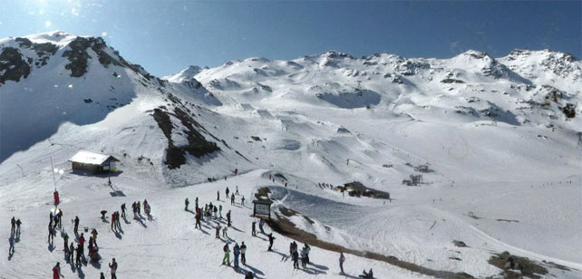
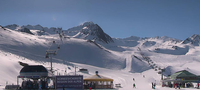
Meanwhile, pictured below is Les Deux Alpes, which closes on April 26, and still has a couple of metres of snow bedded down on its glacier.
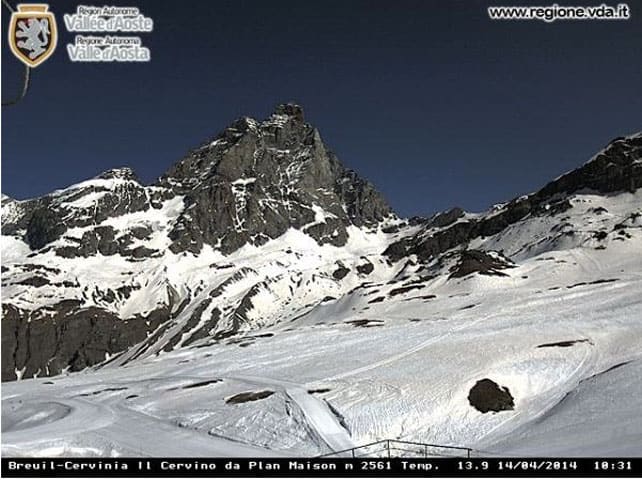
Pictured below is Cervinia, which closes on May 4. Here the snow is 45-295cm deep.
Finally, here is Obergurgl in Austria. The skies are clear this morning – but there should be light snowfall here in the afternoon. Currently there’s 30-108cm of cover, on-piste. The resort closes on May 4.
Fresh snow in the American Rockies
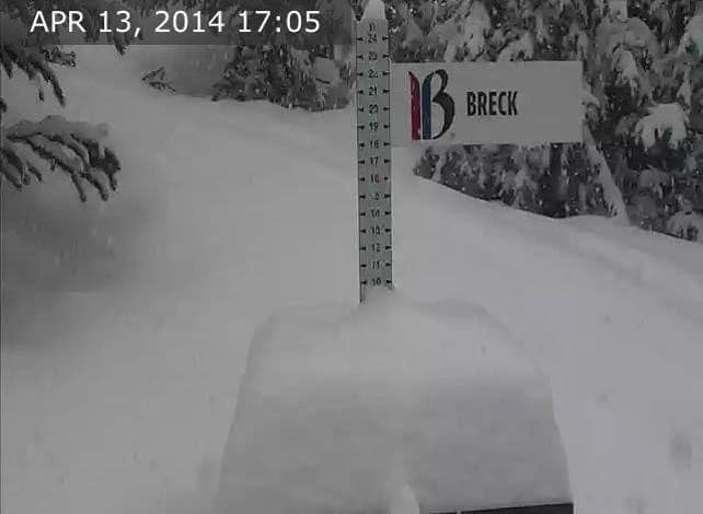
Today is going to be a powder day in the Colorado and Utah Rockies – thanks to the 15-30cm top-up of snow received there yesterday. This is how the snow marker at Breckenridge, Colorado, was looking yesterday afternoon…
According to local snow guru Joel Gatz there should be more snow in the region on Wednesday night, too.
| France: There’s still plenty of good skiing to be had in the high-altitude resorts, although the snow has thinned dramatically below 2000m in recent days. The good news this week is that with cooler winds the rate at which a sunny piste turns from hard to soft will slow down – and as a result conditions won’t be so slushy after lunch. Currently, Val d’Isere reports 49-131cm of settled snow on its pistes. On the Grands Montets above Chamonix the snow report records 77-267cm of cover, on-piste. | |
| Switzerland: eastern Switzerland should see snow this evening and tomorrow. In the west it should sunny and cooler than of late. Currently, in Saas-Fee the cover is 38-328cm deep, on piste. Meanwhile, Verbier reports cover that is 10-150cm deep, and the descent all the way down into town is still in decent condition, although the snow is thin at the bottom. | |
| Austria: Austria had up to 10cm of snow yesterday and some resorts will see 30cm more over the next couple of days. Currently, Obergurgl reports 30-108cm of settled snow on its pistes, St Anton 15-120cm, and the Hintertux glacier up to four metres. | |
| Italy: many of the lower ski areas in Italy have already shut their lifts (including those around the Sella Ronda in the Dolomities). However, at altitude, there’s still plenty of snow. Currently, in the Aosta Valley, Cervinia has 45-295cm of settled cover on its pistes. Meanwhile on the Presena glacier above Passo Tonale there’s still 550-600cm of settled snow, after an exceptional winter. | |
| Andorra: there’s one more week for the season left to run in the Grandvalira ski area – home to Soldeu and Pas de la Casa. There, the snow is 40-160cm deep. | |
| Western USA: last week saw a change from snowy to spring-y in the American Rockies. But now the weather has swung back to snowy again, especially in Colorado, where resorts clocked up 15-30cm of weekend snow. Meanwhile, in Utah, Snowbird reported 15cm of fresh snow from the same storm. More of the white stuff is expected midweek. | |
| Western Canada: it was a mild weekend in Whistler and that trend continues today, with a high of +5C expected on the higher slopes. However, temperatures will be dropping back later this week, with some snow predicted for Thursday. Currently, there’s 241cm of settled snow, mid-mountain. Meanwhile, in Lake Louise there was 12cm of snow over the weekend. The next couple of days look snowy too, before skies clear and milder weather settles over the resort. Currently, there’s a settled snowpack of 202cm, mid-mountain. |


Add Comment