


It’s going to be another magnificent day in the Alps – especially for anyone skiing a resort with lots of north-facing slopes above the 2000m mark.
Here’s how it’s looking this morning in above Val Thorens in France. The resort was hit by the band of snow which swept across the Alps on Friday, and got a 15-20cm top-up as a result. There was a little more snow on Saturday night too. But today will be all about the sunshine.
It’ll be mild too. That’s not going to be much of an issue up here. The village at Val Thorens’ sits at 2300m, and several of the lifts rise to 3000m. But lower down the quality of the snow is going to suffer. Meteo France’s avalanche service reckons the freezing point will be at 2000m today: as a result, on slopes that get a lot of sun there’s going to be melting below 2400m. On shadier slopes it will stay cold and powdery down to 2000m.
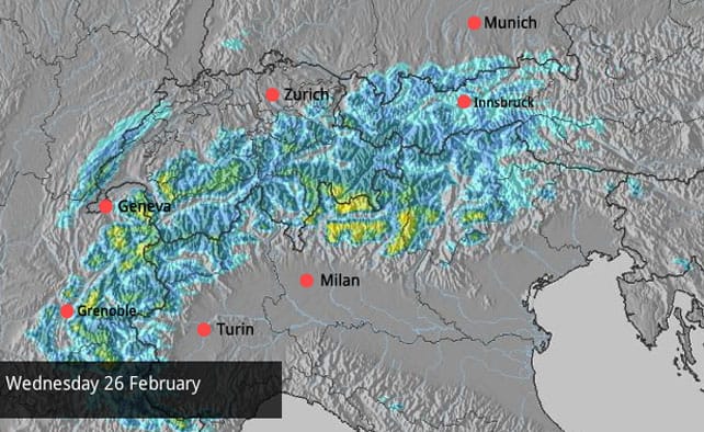
In other words, there’s going to be a spring-like quality to skiing today – and it’ll be like that across the whole region. Many resorts across the northern Alps had 10-20cm of snow as a result of last Friday’s storm. There was snow in the south-east too: in the Italian Dolomites some resorts had 30cm. But now it’s going to be mild. You’ll need to ski above 2000m and stick to the shadier slopes to get the full benefit of the fresh snow.
According to our snow forecast for the Alps, the next snow is expected on Wednesday – and maybe 30cm will fall in a few places. However, high pressure will be the dominant theme of the week, and it’s going to blunt the force of any weather fronts crossing the region. Looking further ahead, temperatures should drop significantly next weekend, and there could be heavier snow – but it’s too soon to be sure of that yet.
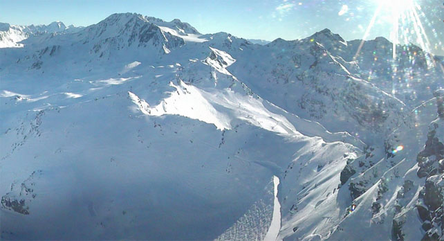
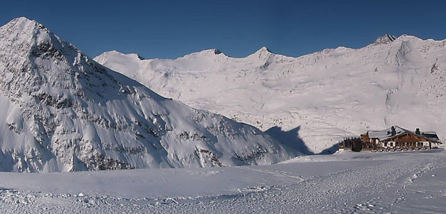
Here’s a brief sample of today’s webcams as the day gets going, starting with Les Deux Alpes, where current snow depths, on-piste, range from 75-220cm.
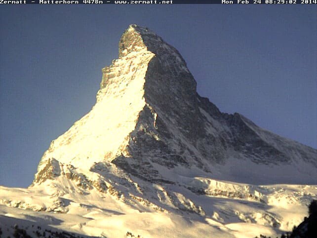
Pictured below, this is the morning sunlight on the Matterhorn in Zermatt, in Switzerland, where the snow is 90cm deep in the valley, and 330cm at 2900m.
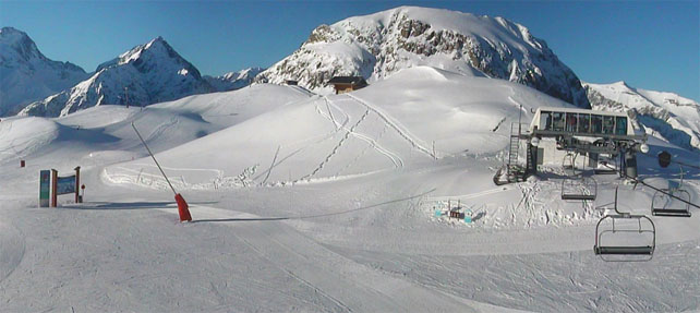
Below is high-altitude Obergurgl in Austria, which will be another great place to ski today. The snow here is 76-151cm deep, depending on altitude.
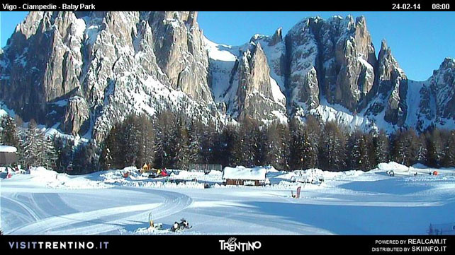
Finally, pictured below is Catinaccio near Canazei in the Dolomites, home to the lovely Baita Checco mountain restaurant. In the Val di Fassa, the snow is currently 95-330cm deep.
Big snow in the parts of the Rockies
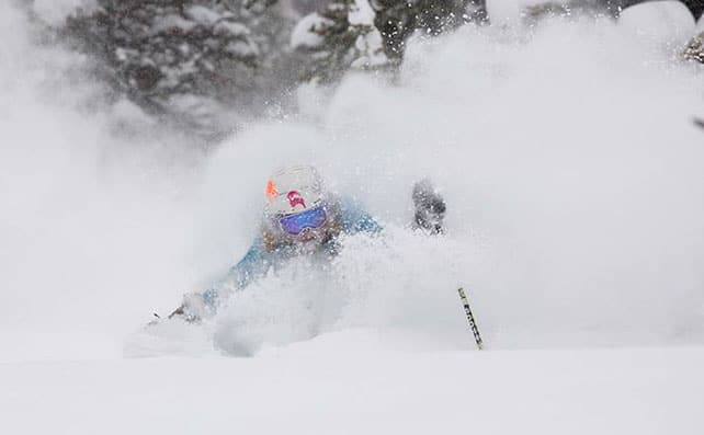
The last few days have seen magnificent dumps of powder in parts of the Canadian and American Rockies. Up in Canada, Fernie has had a cracking week, notching up 92cm in the week to Sunday. Its settled mid-mountain snowpack is now 280cm deep.
Even better has been the snow in Jackson Hole, Wyoming, where over a metre of the white stuff fell in the four days up to Sunday. Jackson keeps a chart comparing the total snowfall in many of the leading Rocky Mountain resorts, and is currently a metre of ahead of its nearest rival (which is Breckenridge, Colorado).
Below is the latest Facebook photo from Jackson. “It’s Groundhog Day this February in Jackson Hole,” says the resort. “Every day we wake up to more snow.”
Further south, in Colorado, there was 10-15cm of fresh snow overnight.
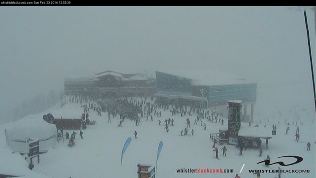
The other big story of recent days has been the rebirth of Whistler’s ski season, thanks to a meaty sequence of storms over the last couple of weeks. After a skinny first half the season, it’s been a huge relief to the powder-hungry locals. Here’s the video the resort posted recently to celebrate.
It was snowing again there yesterday, too. Here’s how it was looking at the top of the Whistler mountain gondola in the afternoon.
| France: see our main report, it’s a spectacular day in the French Alps. It’s mild too, and the best snow will be found above 2000m in the shade and above 2500m in the sun. More snow is expected on Wednesday. Currently, Val d’Isere reports 121-179cm of settled snow on its pistes, Val Thorens 130-230 and Montgenevre 180-230cm. | |
| Switzerland: as in France, conditions are superb this morning in most Swiss resorts – especially if you’re skiing at altitude. There’s likely to be a further top-up of snow on Wednesday, although few places will see more than 10cm. Currently, little Andermatt has cover 105-400cm deep on its slopes. Meanwhile, in the west, Verbier reports cover 60-177cm deep, and in the north Laax has snow 35-150cm deep. | |
| Austria: There was fresh snow across many Austrian resorts on Friday. However, the freezing point will be at 2000m today, so you’ll have to ski at altitude to get the benefit. Only a little snow is expected in the west of the country on Wednesday. There’s still a sharp contrast between snow depths in the north, and the south. Currently, the Skiwelt in the north reports cover 35-65cm deep. By contrast, in Nassfeld in the south, the snowpack is a whopping 150-460cm deep. Meanwhile, in the west St Anton reports 60-140cm of settled snow on its pistes. | |
| Italy: the Dolomites had a good dump on Friday, but the snow seems to have missed many other Italian resorts. No matter – in the wake of the December and January storms, the snow is still, though it will be mild today. Little Madesimo, for example, is still reporting a settled snowpack of 300-500cm. Meanwhile, in the Aosta Valley, Cervinia has 180-320cm of settled snow, and Canazei in the Dolomites 95-285cm. | |
| Andorra: the cover is still deep across the Pyrenees, with Soldeu reporting 120-230cm of settled snow on the pistes. Across the border in Baqueira in Spain, the snowpack is 215-305cm deep. | |
| Western USA: the Pacific northwest and the northern half of the American Rockies have been having the best of the snow lately – although down in Colorado there have been several top-ups lately, too. Meanwhile, in California, skiers are looking forward to heavy snow at the end of the week, thanks to a couple of meaty storms approaching from the Pacific. In Wyoming, Jackson Hole currently has 243cm of settled cover, mid-mountain, Breckenridge in Colorado has 229cm, and in Utah, The Canyons reports 152cm. | |
| Western Canada: see our main report. Yesterday, Whistler reported 87cm of snow in the last week, and 218cm of settled cover mid-mountain. In Banff National Park, Lake Louise has had 25cm of new snow in the last week and reports 159cm of settled cover. |


It’s going to be another magnificent day in the Alps…
https://t.co/LvvBqb8nA2
#Snow Report, February 24 https://t.co/ddyFNJSj8g via .@welove2ski