


There are two big talking points today, Snowfiends…
1. Winter’s back in the Alps
After the sharp thaw at the start of the week, temperatures have dropped back across the Alps, and there’s fresh snow this morning in France and western Switzerland, spreading east during the course of the day.
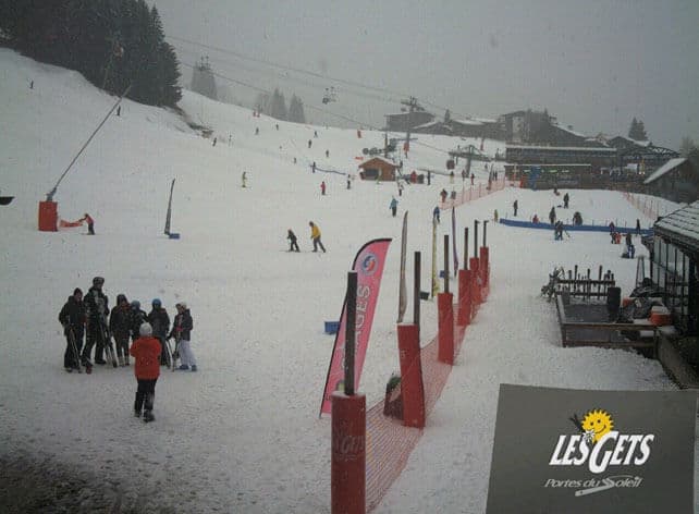
It’s still raining lower down. In Morzine this morning, for example, the streets are looking rather wet, but there’s snow not much higher – at 1200m in Les Gets, nearby. Here’s how the nursery slopes were looking earlier.
Higher up, in Chamonix, they’ve had 20cm overnight, and it’s still snowing – although as you’ll see from the morning Boardriders report, below, high winds and low-cloud are making it tough going.
ARVE Error: For the maxwidth (maxw) option you need to have normal or lazyload mode enabled, either for all videos in the plugins options or through shortcode e.g. [youtube id=123456 mode=normal maxw=999 ].
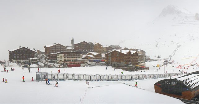
It’s snowing hard in Tignes too, where the settled snow is 145-270cm deep. There’s been about about 15cm of fresh snow overnight.
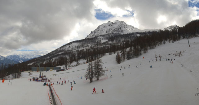
Here’s how it’s looking in Serre Chevalier, where there was 10cm of snow yesterday. The cover is 20-150cm deep.
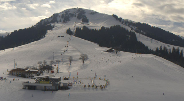
As you’ll see from the shot of Soll in the Tirol, below, the snow hasn’t reached the eastern Alps yet, but it will. Most Austrian resorts are expecting 10-15cm by tomorrow morning – although those on the Italian border will get less. In Soll, the snow is currently 55-65cm deep.
Up high, the new snow is adding to light to moderate falls from earlier in the week. Off-piste, the wind is moving it about, and forming unstable wind slabs, so the avalanche risk is now considerable at 3/5 in most resorts in France, Switzerland and Austria. The condition of the snow is very mixed too – with patches of frozen crust on south-facing slopes, mixed in with powder and hard-packed wind-blown snow. Below about 2000m, the snow is quite humid and heavy.
On-piste, the new snow and low temperatures will combine to create a much-improved skiing surface, compared with the thaw-affected slopes at the beginning of the week. However, temperatures will be creeping up at the weekend, so you’ll need to ski on the top half of your lift system if you want proper, wintry snow.
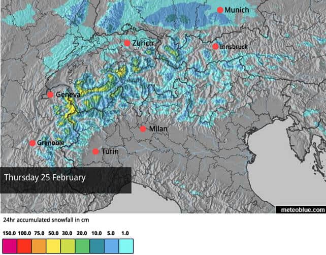
2. The Pyrenees and the Italian Alps are about to get the storm of the season
For several days, a big Bay of Biscay storm system has been predicted by the mid-range weather charts. It’s still there – promising sizeable dumps in both the Pyrenees and the Italian Alps – and it’s starting to show up in Welove2ski’s snow forecast, too.
Just look at it…
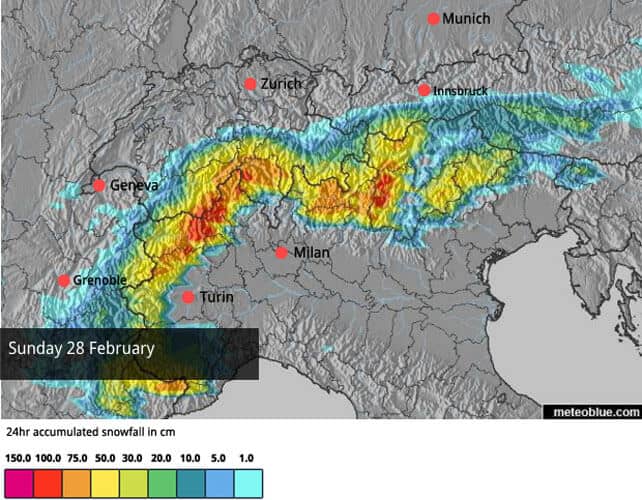
I wouldn’t bet the house on it just yet. And we won’t know until the last minute who’ll get the most snow. But the storm of the season is now likely – and a metre or more of snow in 24 hours is probable in some resorts. At the moment, it looks as though the Monterosa resorts of Champoluc, Gressoney and Alagna, as well as Madonna di Campiglio in the Brenta Dolomites will be hit hardest, but almost every Italian resort will see heavy snow. The Maurienne Valley in France, and parts of southern Switzerland and Austria should also see plenty of the white stuff.
Meanwhile in North America…
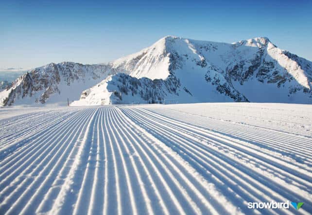
There’s been another break in the generally mild and settled weather across the American Rockies, thanks to a weather front that crossed Utah and Colorado on Monday night. Many resorts had only a dusting, but in Utah, Alta and Snowbird picked up 15cm of new snow and so did Breckenridge in Colorado.
Here’s how the new snow looked on Tuesday, groomed into the pistes in Snowbird.
Meanwhile, Breckenridge posted this short video…
ARVE Error: For the maxwidth (maxw) option you need to have normal or lazyload mode enabled, either for all videos in the plugins options or through shortcode e.g. [youtube id=123456 mode=normal maxw=999 ].
Now, the sunshine’s back. The Pacific Northwest should see the next significant snowfall, with a good chance of storm at the weekend affecting resorts such as Whistler. This should also spread into the Canadian Rockies, and Montana and Wyoming.
| France: temperatures have dropped and there’s fresh snow – a big relief after the thaw at the beginning of the week. Lower down, the new snow is rather humid, but above about 1700m it’s more wintry, and once it’s groomed into the pistes skiing conditions will be considerably improved. Off-piste, conditions are mixed bag of windslab, powder, and frozen crust, and the avalanche risk is at 3/5 – so hire a guide and stay safe. Temperatures will nudge up a bit at the weekend, but we’re not expecting another thaw like Monday’s. Currently, Val d’Isere has 138-268cm of settled cover, on-piste, and Courchevel 137-195cm. | |
| Switzerland: conditions across the northern and western resorts of Switzerland are quite similar to the northern resorts of France: there’s been snow at altitude, rain lower down, and now temperatures are dropping back to more seasonable levels. Currently, Verbier, reports 5cm of fresh snow overnight and 38-235cm of cover, on piste, and Engelberg 30-350cm. | |
| Austria: Austria’s resorts are expecting fresh snow today – and those near the border with Italy should see plenty more on Sunday. Generally, the cover isn’t as deep as it is in France, but the resorts of the Arlberg are a notable exception. Currently, the Skiwelt has 55-65cm of settled snow, on-piste, while St Anton reports 65-280cm. | |
| Italy: all eyes in Italy are now on the Sunday snow forecast. Resorts here were affected by the thaw at the start of the week, and while there’s more than enough cover on-piste the ungroomed slopes are looking thin again. However, if the predictions are correct, more than a metre of snow could fall in places at the weekend. Expect road closures and – maybe – power failures, as well big smiles from off-pisters and ski tourers. Currently, high-altitude Cervinia reports 50-230cm of settled snow. In Canazei in the Dolomites it’s 40-95cm deep. | |
| Andorra: the Pyrenees are expecting the storm of the season this weekend – and driving conditions are likely to be very difficult on changeover day as a result. In Andorra, Pas de la Casa has up to 100cm of cover packed down, on-piste, but the pistes are rather wet and heavy today. | |
| Western USA: see our main report. The second half of January saw the snowstorms coming thick and fast across the American west – followed by an extended mild spell. There have been occasional snowy spells to break things up, but generally conditions are sunny and spring-like. There are signs that snowier weather may return next month. Currently, in Colorado, Breckenridge reports a healthy 162cm of mid-mountain snow, in Utah Snowbird has 226cm, and in California Heavenly has 216cm. | |
| Western Canada: in Whistler the mid-mountain snowpack is 249cm deep, and the weather is sunny and mild. Sunday should see a change, with a drop in temperature and more snow. In Banff National Park, Lake Louise reports a mid-mountain snowpack of 119cm. It’s also expecting a mild and sunny day. |


Add Comment