


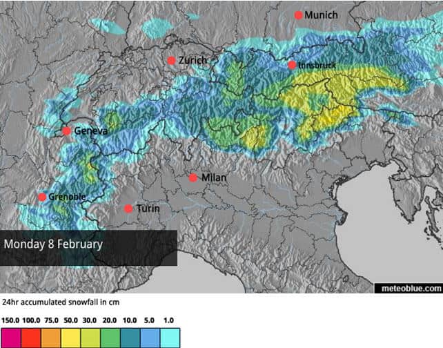
It’s hard to keep up with the weather in the Alps at the moment. Monday saw ridiculously high temperatures for February 1, which were followed by a sudden burst of cold, accompanied by moderate to heavy snowfall across the northern Alps. Parts of the Arlberg in Austria have seen a metre of fresh snow in the last week. Several areas in Switzerland have had 60cm in the last three days.
Generally-speaking, the avalanche risk is considerable, at 3/5, although there are local variations. This morning, the risk in the Engadin valley, around St Moritz, is at 4/5, even though the snow hasn’t been especially heavy there.
Now, the skies are clearing from the west, and temperatures are climbing rapidly. This afternoon in the French Alps, for example, the freezing point is expected to hit 2700m. It’s going to be rather spring-like, in fact; with skiers racing to enjoy as much of the new snow as possible before the sunshine and mild air make it wet and heavy.
The sun should persist tomorrow, but temperatures will be dropping back slightly, before things get interesting on Sunday. There’s a period of turbulent weather on the way, although the forecasts aren’t in agreement yet about how it’ll work out. There will be heavy snow in places, but temperatures are likely to yo-yo about and there’s a good chance of rain in low-lying resorts.
One striking feature of the this stormy spell is that the Italian Alps could finally see there first heavy snowfall of the season. Regular followers of the snow report will know that the snow-making crews in many Italian resorts have created very good on-piste cover with their snow-cannons. But all the same, they’d love to have a bit of help from Mother Nature – and the freeride and ski-touring communities will heave a huge sigh of relief, too.
Welove2ski’s current snow forecast for Sunday looks promising for the eastern and central resorts in Italy.

And Monday’s forecast looks good for the Dolomites.
Let’s hope they stay that way!
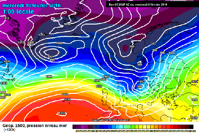
I also like the look of the current forecast for Wednesday from the European Centre for Mid-Range Weather Forecasts, shown on Meteociel. But it’s too soon to be sure it’ll come to pass.
Generally speaking, the Alps will be on the frontline between a mass of cold air, and much warmer temperatures in the south, and marginal adjustments to weather patterns will produce quite sharp and sudden changes.
Still, the higher resorts should have plenty of new snow on their slopes in time for February half term.
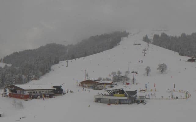
Right, onto the morning’s webcams, starting with Soll in the Skiwelt which had 20cm of snow overnight, and has settled cover 55-60cm deep, on-piste.
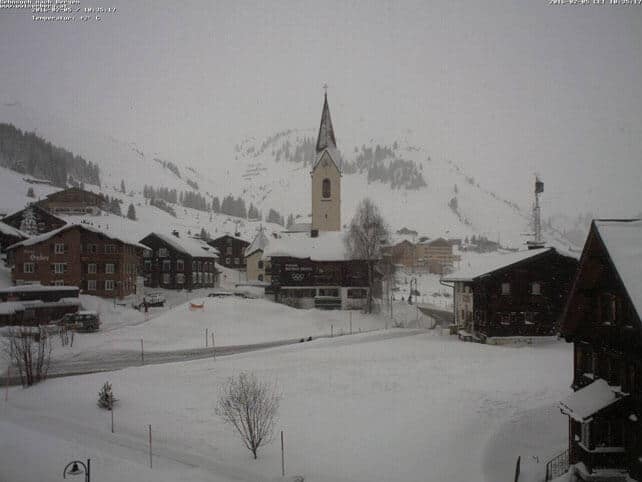
Meanwhile, here’s how it’s looking in Warth, which is connected to Lech in the Arlberg. Here, there was 25cm of fresh snow overnight, and the cover is 116-205cm deep on-piste.
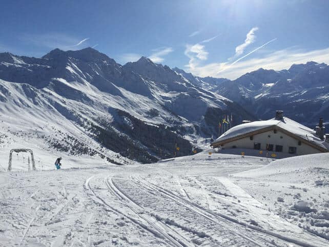
Pictured below is Verbier, where two of our editors are this morning, lucky things. There was 20cm of snow overnight and the cover is 42-205cm deep. “A gorgeous day!” sums it up nicely.
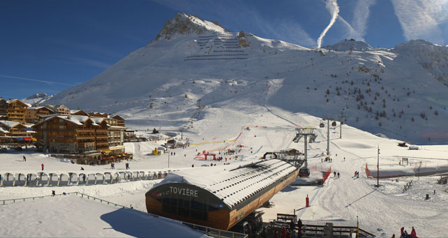
Pictured below is Tignes, where the snow is 121-215cm deep.
And this is Serre Chevalier, south of Grenoble, which hasn’t enjoyed quite the same snow bonanza as the northern resorts since the start of January – but is expecting significant snowfall on Sunday and Tuesday. Here, the cover is 20-115cm deep.
Meanwhile, in North America
Across the American west it’s been a memorable few weeks. A seemingly endless succession of storms has kept resorts topped up with powder, and there have been some memorable dumps in some resorts. Now, however, Mother Nature is taking a breather. A weak frontal system has added few inches of snow in Colorado, Utah and Wyoming overnight, but high pressure is about to take over, and will bring an extended spell of sunshine and mild temperatures to the region. The time to ski soft, cold wintry powder is right now. Next week, the best skiing will be on the groomed trails.
It’s not yet certain when the sunny weather will break down. The weekend of February 13/14 could see a change. But most forecasters are looking beyond that, to the last ten days of February.
As we all know, American resorts aren’t shy about showing off their snow, and there have been some gorgeous videos and photos around lately. If the sight of other people enjoying powder is going to make you jealous, you’d better look away right now…
Here’s Heavenly, above Lake Tahoe in California, on February 1.
ARVE Error: For the maxwidth (maxw) option you need to have normal or lazyload mode enabled, either for all videos in the plugins options or through shortcode e.g. [youtube id=123456 mode=normal maxw=999 ].
And this is a video of conditions in the last four days in Beaver Creek, Colorado.
ARVE Error: For the maxwidth (maxw) option you need to have normal or lazyload mode enabled, either for all videos in the plugins options or through shortcode e.g. [youtube id=123456 mode=normal maxw=999 ].
And here’s some mind-blowing footage from Jackson Hole. It’s not especially recent, but more than worthy of inclusion because – well, look…
Weezy Ways Episode 1: Skiing is FUNK from Tyler Van Martin on Vimeo.
| France: the last three days have been wintry in the French Alps, and have left snow even in the lowest resorts – which is a big relief after the rain on Sunday And Monday. However, rising temperatures will affect the cover today right up to 2700m on sunny slopes, and there could be rain again, lower down, when the next weather fronts hit. But on middling and high-altitude slopes heavy snow is expected over the coming days. It’ll be the perfect preparation for February half term. Currently, Courchevel in the Three Valleys has 106-175cm of settled cover, on-piste, and Chamonix 178-270cm on Flegere. | |
| Switzerland: conditions across the northern and western resorts of Switzerland are quite similar to the northern resorts of France: the snow’s fresh and deep, and the weather spectacular. But it is warming up again. Fortunately, it won’t be long before the next dump. Currently, Verbier, reports 42-205cm of cover, on piste, and Engelberg 40-335cm. | |
| Austria: Austria’s resorts have benefitted from the week’s snow, coupled with a drop in temperature, and offer excellent skiing today as the skies clear. They’ll miss out on the heaviest snowfalls of the next four days, and the cover could suffer a bit under clear skies and southerly winds. However, there’s a good chance of heavy snow from Wednesday onwards to repair the damage. Currently, the Skiwelt has 55-60cm of cover, and St Anton 80-210cm. | |
| Italy: still the watchword is “more snow please” in the Italian Alps, although the snow-making crews have done a sterling job of compensating for Mother Nature’s shortfall. However, the forecast is looking promising at last for Sunday and Monday next week. Currently, high-altitude Cervinia reports 50-210cm of settled snow. In Canazei in the Dolomites it’s 20-80cm deep. | |
| Andorra: the Pyrenees haven missed out on much of the recent snow that’s fallen in the Alps, and it’s been mild too. So resorts are leaning heavily on their snow cannons to keep the pistes in good nick. Fortunately they are due some snow at the weekend. In Andorra, Pas de la Casa has up to 60cm of snow packed down, on-piste. | |
| Western USA: see our main report. The second half of January saw the snowstorms coming thick and fast across the American west. But Mother Nature is about to take a breather, with a week of sunny and mild weather on the cards. Currently, in Colorado, Breckenridge reports a healthy 147cm of mid-mountain snow, in Utah Snowbird a whopping 223cm, and in California Heavenly has 210cm. | |
| Western Canada: Whistler is expecting 10-20cm of snow today on the top half of its ski area, before high pressure builds and the sun comes out. Currently, the mid-mountain snowpack is 208cm deep, and conditions will be excellent in the high Alpine sections of the ski area, before it starts to warm up. In Banff National Park, Lake Louise reports just 15cm of new snow this week, and a mid-mountain snowpack of 95cm deep. Temperatures are good and wintry at the moment: although it will warm up next week. |


Add Comment