


Conditions in the Alps have improved significantly over the last fortnight: and they’re about to get a whole lot better, thanks to two weather fronts due in this week.
The first arrives this afternoon and, if our snow forecast is correct, it’ll sweep quickly across the north-western Alps before settling over eastern Switzerland and Austria. Resorts there could see 20-30cm of fresh snow tonight and tomorrow. We still can’t be absolutely sure of those totals, as a finger of high pressure pointing at the Alps from the west may yet weaken its impact. But most resorts north of the Italian frontier can expect at least a top-up.
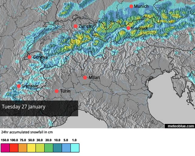
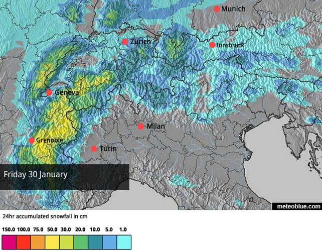
Then, on Thursday evening, comes the main event; a big lump of cold, snowy air moving down from the Arctic that’s had the ski community buzzing since last week. The good news is that the forecasts are still unanimous the storm is coming, although estimates of how much snow will fall vary wildly, and will probably continue to do so for the next couple of days. (Last week, some mid-range forecasts were predicting over a metre of snow for Chamonix in 24hrs, on January 30. Now, they’re estimating 40-50cm.) Nevertheless, it’s looks certain that a lot of snow is on the way, and that it’s likely to favour the French Alps, Switzerland and the Pyrenees. The Italian Alps should see a little snow too: but a lot less than the northern half of the region.
Here’s the snow forecast for the Alps for Friday.
We can expect the detail to change a bit over the coming days, but the overall message seems clear. If you can get out to the Alps this weekend, or immediately afterwards, GO. And for heaven’s be careful if you’re planning to ski off-piste. Expect the avalanche risk to rise sharply. Hire a guide, and make sure you’re properly equipped. And read this avalanche survivor’s story to bring down your testosterone levels a notch or two.
It’s also worth bearing in mind that mid-range forecasts are predicting the return of high pressure and mild air to the region towards the end of next week, especially across the western end of the Alps. That doesn’t mean a return to the snowless slopes of mid-December: but the cover in lower resorts will be affected by a cycle of daytime melting and overnight refreezing, if the thaw comes. If you want to be sure of top-quality, squeaky snow in the weeks to come, then you’d be well advised to play it safe, and aim high.
Right, onto today’s webcams, starting with this rather tasty shot of the top of Schmitten at lunchtime, above Zell am See. I’ve just blown into the resort for four days of skiing to discover they had a 10cm top-up overnight, and snow depths at the top of the local mountain are 92cm. On the Kitzsteinhorn glacier, nearby, they’re up to 270cm. I’d love love LOVE to be skiing up there right now, but there’s a Snow Report to be written, see? Still, at least tomorrow’s forecast looks good. It seems as though I’ve timed my arrival perfectly…
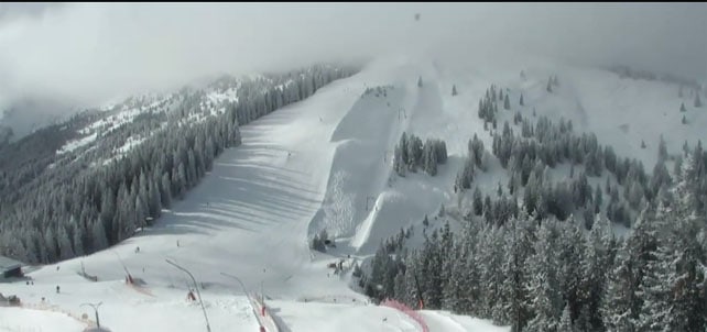
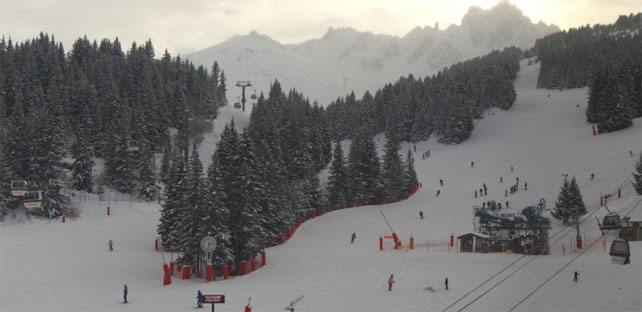
Meanwhile, pictured below is how it was looking above Soll in the Skiwelt this afternoon. The cover here is 45-55cm deep, and there’s 5cm of fresh snow on the slopes, too.

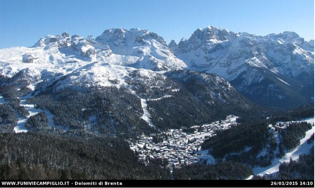
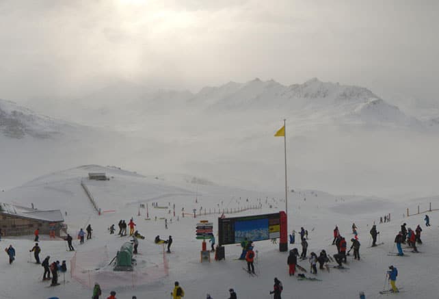
Below, was scene earlier in Madonna di Campiglio today. Madonna was one of the resorts in the south-central Alps which was walloped by snow on January 18. It had 50cm in day, with a further 15cm top up on Wednesday. Livigno and Madesimo, a little to the west, had even more. Currently, the snow is 65-165cm deep on the pistes.
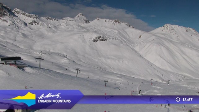
Pictured below is St Moritz in Switzerland, which also saw heavy snow a week ago. Settled snow depths on the lower pistes are half a metre deeper there than they were at the beginning of the month.
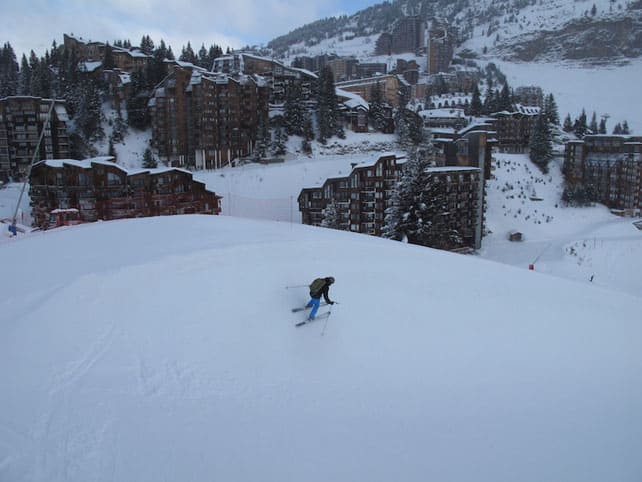
Pictured below was Avoriaz this morning. Fellow Welove2ski editor Peter Hardy is skiing here, and reports a chilly start to the day, with temperatures not much above -11C. “At last, we have really good snow conditions here and the promise of more to come,” he says. Snow depths are suddenly looking impressive here. There’s up to a metre of cover on-piste at 1800m and 150cm at 2500m.
Here’s the scene at La Croisette in Courchevel today, where the snow is 54-89cm deep, on-piste.
And this is Val d’Isere, which has 51-110cm of settled snow on its pistes. In common with all French resorts, it should have plenty more by this time next week.
| France: conditions in the French Alps have improved considerably in the last eight days, following 10-15cm of snow on January 14, 20-45cm on the weekend of January 17 and 18, and light-to-moderate snowfall since then. The resorts of the Portes du Soleil, especially Avoriaz, have done particularly well, and have enjoyed cool temperatures for the last fortnight, too. All eyes are now on the forecast for the end of the week. Let’s hope it delivers, without causing too much travel disruption in the process…
Currently in high-altitude Tignes there’s 51-100cm of cover, on-piste: the lower pistes are getting a little hard-packed now, but up on the Grande Motte glacier, they’re still soft. Meanwhile, in the Three Valleys, Val Thorens reports 90-130cm of snow, on-piste. |
|
| Switzerland: in western Switzerland, the situation is very similar to France. All resorts are in better shape now, though you’ll still find the best skiing at altitude. Here, heavy snow is expected on Friday and over the weekend. Further east, there’s good skiing too, and it should be even better on Wednesday, in the wake of the fresh snow expected tomorrow. Currently Verbier, in the west, has 20-105cm of cover on its pistes, Laax in the east reports snow depths of 50-250cm, and St Moritz, has 52-141cm. | |
| Austria: most Austrian resorts had 10cm of fresh snow yesterday, and should get 20-30cm more tomorrow if the forecast is correct. With temperatures set to stay low, this will be a great week to be out on the slopes: although it’s not expecting to see heavy snow from the weekend storm. Currently, in the Arlberg Lech reports cover 55-105cm deep, and in the northern Tirol the Skiwelt has 45-55cm on its pistes. Meanwhile, in the east, Schladming has 60-95cm of settled snow on its pistes. | |
| Italy: parts of the Italian Alps were walloped by snow last week: others saw more moderate falls. Either, way, the skiing has improved after a dry and mild start to 2015. It’s shame, though, that the Italian Alps won’t get much of the new snow forecast for the coming week: another dump would do the lower slopes no end of good. If you’re planning a visit in the near future, target somewhere high-altitude such as Cervinia, where the snow is currently 150cm deep, mid-mountain. Or aim for one of the resorts which had heavy snow on January 18, such as Livigno or Madesimo. In Madesimo, the cover is currently a whopping 170-430cm deep. | |
| Andorra: in Andorra, the Grandvalira ski area reports a respectable 50-110cm of cover on its pistes, and is looking forward to heavy snow at the end of the week. | |
| Western USA: in the US, all eyes are on the big storm that’s about to engulf the east coast. Sadly further west, in the Rockies, it’s looking much less wintry this week, with daytime highs of +7C expected in many Colorado resorts. There’s going be a little wet snow midweek, and then high pressure will probably return – although it will at least be cooler. Currently, Vail in Colorado has 104cm of snow packed down, mid-mountain, Jackson Hole in Wyoming has 172cm of cover, mid-mountain, and Snowbird in Utah 165cm. | |
| Western Canada: after a mild weekend, the weather in Whistler is going to cool down again, and some light snowfall is expected. Currently, the snowpack is down to 124cm, mid-mountain, which isn’t much by Whistler standards. It’s been a very ordinary season, snow-wise so far. Inland, conditions have been more consistently wintry, but even Banff National Park has succumbed to the mild spell. Lake Louise is expecting a high of +4C today, which is spring-like by its chilly standards. Currently its snowpack is 122cm deep, mid-mountain. |


Add Comment