


We’re not done with winter just yet. Lower temperatures and a little fresh snow are expected in the Alps this weekend, and there are signs a more substantial snowy blast may hit the region on Wednesday.
Meanwhile, across the Atlantic, western Canada has been getting some much-needed snow. There’s more to come, too.
Apologies for the late arrival of this Snow Report, but at least it’s the bearer of good news for the Alps for the coming week.
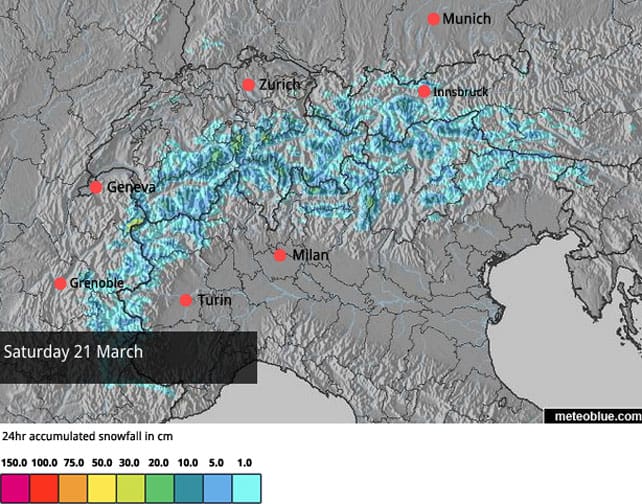
It’s now pretty certain that there’ll be a drop in temperatures and light-to-moderate snowfall across the region at the weekend. A cool north-easterly wind will be blowing, and in the French Alps the freezing point could drop to 1000m for a time on Sunday, down from a high point of 2500m today. In Austria, the freezing point is expected to be at 1500m on Sunday.
Here’s the current snow forecast for the Alps on Sunday, which suggests up to 20cm could fall in a few places.
And here’s the snow forecast for Monday.
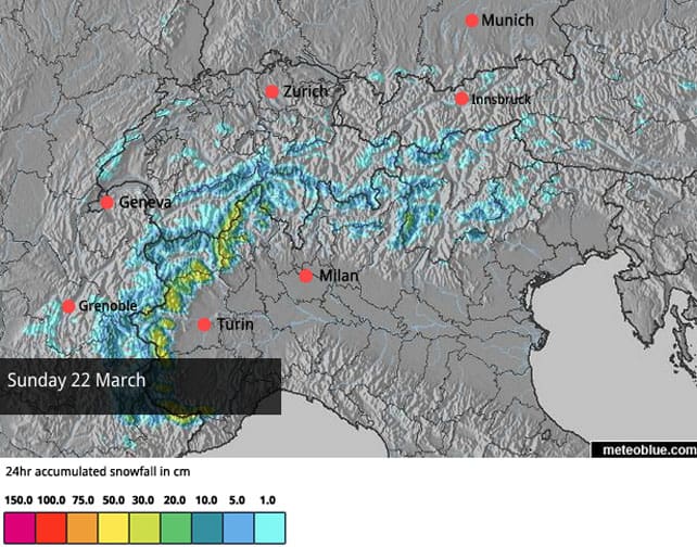
You’ll notice that Monday’s forecast is favouring Piedmont and the Aosta Valley in Italy again. As you’ll know from Monday’s Snow Report, it was here that the last heavy snow fell in the Alps. In Piedmont, Bardonecchia reported 50cm on its upper slopes on Tuesday, and in the Aosta Valley, Pila had 30cm. The storm also spread east along the Dolomites (bringing 15cm to Madonna di Campiglio), and also strayed across the border into parts of France, Switzerland and Austria. For example, Val d’Isere generally had 15cm from the storm, although there was more up on the Pisaillas glacier.
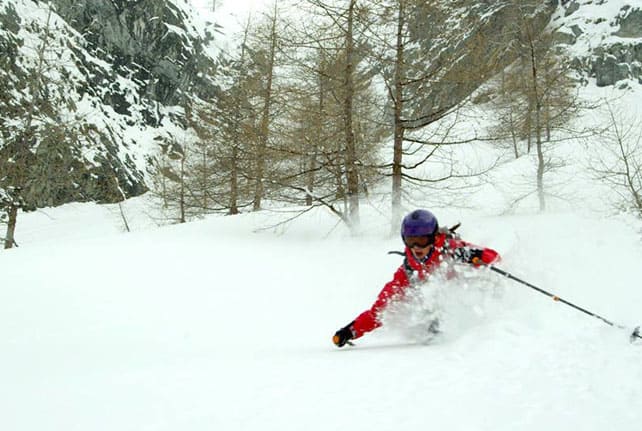
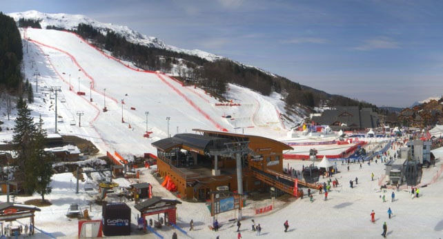
Here’s how it was looking in the Monterosa ski area just after the snow had fallen.
This time, the snow will be lighter, but it’ll be a welcome top-up, nonetheless. For the time of year, conditions are very good in this sector, and will remain so: although you will have to take account of the strength of the sun. Whenever it comes out you’ll find fresh snow on south-facing slopes turning humid and heavy in an instant.
Further north, away from the recent snowfall, conditions are reasonable, considering it’s mid-March – but snow has been thinning very quickly on the lower slopes this week, even where they face north. Below about 1500m on south-facing slopes, many pistes are now ribbons of white against the grass. As a result, all eyes are on the forecast for Saturday and Sunday, and the prospects for the days beyond, which are suggesting a more substantial storm on Wednesday.
At the moment, it looks as though high pressure over eastern Europe will restrict the snow to the western Alps at first, before it loops round and hits Italy, and then rolls eastwards. However, it’s a complicated situation, with lots of elements in play, and I expect the detail will change. Let’s all hope it comes though, and peps up the northern Alps just in time for the first wave of Easter skiers, due to arrive on March 28 and 29.
Today, however, it’s sunny and mild almost everywhere, and spring-skiing tactics are essential if you want to find the best snow. Here’s a quick squizz at the day’s webcams, starting with the eastern end of Val d’Isere. Across the resort, the settled snowpack is currently 99-160cm deep, depending on altitude.
Meanwhile, pictured below is the Chaudanne in Meribel, where Alpine Skiing’s World Cup Finals are currently being held. Here the snow is 70-140cm deep, depending on altitude.
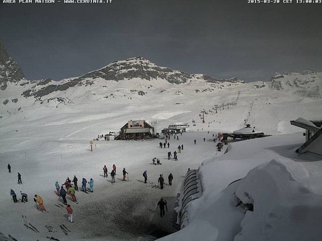
Pictured below is high-altitude Cervinia in Italy, where the snow is currently 45-240cm deep.
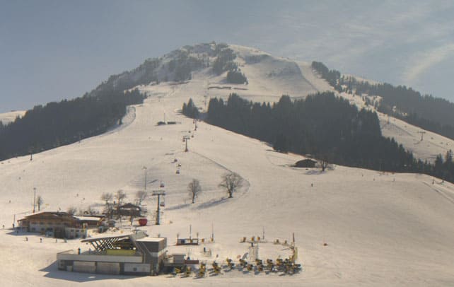
And below is how it’s looking above Soll in the Skiwelt in Austria. As you’ll see, the snow on north facing pistes is holding up well. Snow depths here range between 30 and 60cm.
Meanwhile, across the Atlantic…
Whistler in Canada is getting some much-needed snow. It’s wet and heavy at the moment, but the resort’s notched up 25cm on the upper slopes so far, and the trend is for temperatures to drop. Here’s a rather cute video shot there yesterday.
| France: French resorts near the Italian border saw some snow at the beginning of the week. But they could do with more – and that’s certainly the case in the resorts further north, where the cover’s thin on the valley runs. On all but the highest, shadiest slopes, the snow is now going through a daily melt-freeze cycle, which makes spring-skiing tactics essential. Hopefully, the forecast for the coming week will deliver: but even so, with April on the horizon, this is the time to aim for a high-altitude resort. Somewhere like Tignes, Val Thorens or Val d’Isere will do nicely. Currently, south of Grenoble, Serre Chevalier has 18-130cm of cover, and in the Three Valleys, Val Thorens reports 115-200cm of settled snow on its pistes. | |
| Switzerland: conditions in Switzerland are very similar to those in France. At the moment, it looks as though there’ll be light to moderate snowfall over the weekend, and then – maybe – snow in the middle of next week, although there’s a danger that high pressure in eastern Europe may divert it away to the west. Currently Verbier reports perilously thin snow on the lower slopes, and plenty of cover higher up: 5-200cm are the current snow depths. Meanwhile, Laax in the east reports snow depths of 15-300cm, and St Moritz in the south 45-139cm. | |
| Austria: there was a little snow in central and eastern Austria last week, but the cover in all but the highest resorts has been thinning quickly since then. There’s likely to be a little fresh snow in the west on Saturday and Sunday, and then we’ll have to wait and seen whether next week’s probable storm delivers. High pressure in eastern Europe could, however, deny Austria a proper dump. Currently, in the Arlberg, Lech currently has 70-185cm of cover, on piste, and in high-altitude Obergurgl it’s 25-159cm deep. Meanwhile, further east, Zell am See reports up to a metre of snow at the top of the Schmitten, and nearly three times that on the Kitzsteinhorn glacier. | |
| Italy: the western resorts in the Italian Alps are the place to be right now, thanks to their dump on Monday and Tuesday – with the promise of more to come on Sunday. Still, you still have to bear in mind the gathering strength of the sun, and ski the freshly-fallen snow quickly. In the Aosta valley, Champoluc currently has cover 55-205cm deep, on-piste. Meanwhile, in the east Canazei in the Dolomites reports 40-130cm of settled snow on its slopes. | |
| Andorra: it’s a grey day in the Grandvalira ski area,, with temperatures up to +4C on the slopes. Currently, snow depths are reported to be 140-210cm across the slopes. The good news is that it looks as though there’ll be fresh snow at the weekend, and again in the middle of next week. | |
| Western USA: spring has a strong grip on the Rocky-Mountain weather at the moment, and there’s no immediate end in sight for the southern half of the range. Currently, in Vail, the mid-mountain cover is 124cm deep, and a high of +8C is expected. It’ll be up to +10C at the weekend. In Utah, the Snowbird reports 180cm of settled snow, mid-mountain. Further north, there should be snow at the beginning of the week, which should reach as far as Jackson Hole in Wyoming. The end of the ski season there is April 5, just over a fortnight away. Yikes! | |
| Western Canada: at last, Whistler is getting snow, bringing its season tally so far to 516cm – a miserable amount by the resort’s usual standards. Currently, mid-mountain snow depths are around 166cm. Inland, in Banff National Park, Lake Louise has had an 11cm top-up, and is expecting a high today of +5C. Mid-mountain, the snowpack there is 115cm deep. |


Add Comment