


The weather in the Alps has started to change. There’s already been snow in the east, and there’s more to come. Next week, the white stuff could be settling down to 1000m for a time.
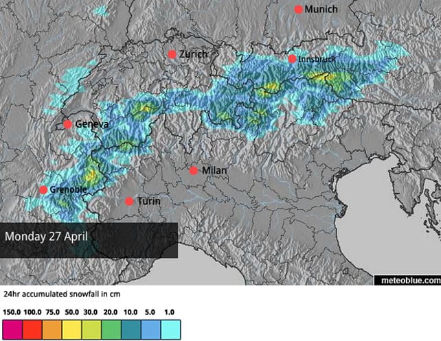
Check out the snow forecast for the Alps for Monday, above. The long, mild and mostly sunny spell that’s dominated the weather for nearly three weeks recently is breaking down, and we can expect several days of very changeable conditions.
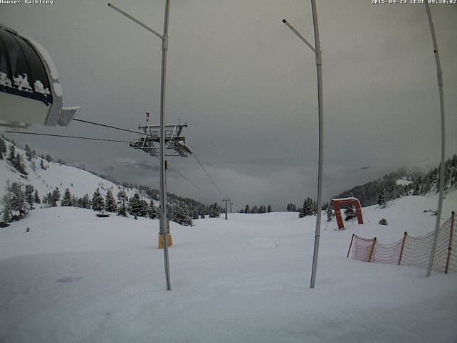
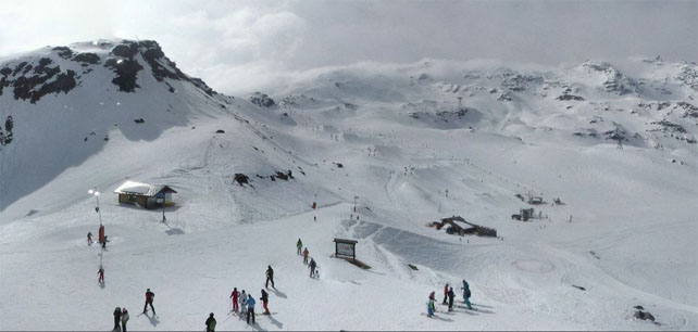
In fact, it’s already been snowing in parts of Austria. Here’s how it’s looking this morning at Hauser Kaibling, part of the Ski Amadé area south-east of Salzburg.
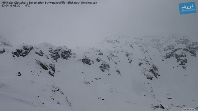
And here’s the Molltal Glacier in Carinthia.
More snow is expected today, and it should creep westwards, into parts of the Tirol too. The Kitzsteinhorn, Stubai and Hintertux glaciers should all get a top-up by the end of the day.
Elsewhere in the Alps, it’s still sunny – but that will change at the weekend, when two separate weather fronts cross the region from the west. The first, on Saturday, is likely to be fairly mild, and there will be rain up to 2200m at least. The second, on Sunday, will be accompanied by a drop in temperature, and – according to French forecaster Meteo Chamonix – the snow could settle down to 1000m. What’s more, the whole of next week is likely to be cooler than in recent days.
Of course, for most ski resorts, this is immaterial, as they’ve either closed already for the season, or will do so at the weekend. Among those shutting their lifts for the last time on either Saturday or Sunday will be St Anton, Obergurgl, Les Arcs and Meribel.
But the ski season isn’t over yet at altitude. In fact, in one or two places it never stops. Val d’Isere is running its lifts until May 3. Tignes and Val Thorens keep going until May 10. Cervinia will be running its lifts at weekends until the end of the month, and in Austria several glacier ski areas, including the Stubai, will be operating well into the summer – at which point several more glaciers across the Alps reopen for summer seasons. Two glaciers stay open the whole year: at Hintertux, and Zermatt (although here there will be some lift repair work going on between May 3 and 24).
If the forecast is anywhere near accurate, anyone who can get out to the Alps in the second half of next week should be in for a treat. Once the skies clear, there will be excellent conditions at altitude, and the pistes will be all but empty. Meanwhile, those who fancy setting their edges to snow in June, July or August, should read our feature on the joys of summer skiing.
Here’s a quick squizz at today’s webcams beyond the snowy parts of Austria, starting with Val d’Isere, where the cover is currently 45-152cm deep, on-piste. Here, it’s still warm, and the temperature at 2000m is likely to hit +11C today. For the best conditions, skiers will need to tackle the sunny pistes first thing and then stick to north-facing slopes, or head to one of the glaciers.
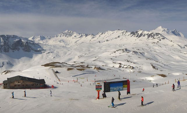
Pictured below is Val Thorens, where the cover is 90-210cm deep. Here the freezing level will be up to 2900m this afternoon.
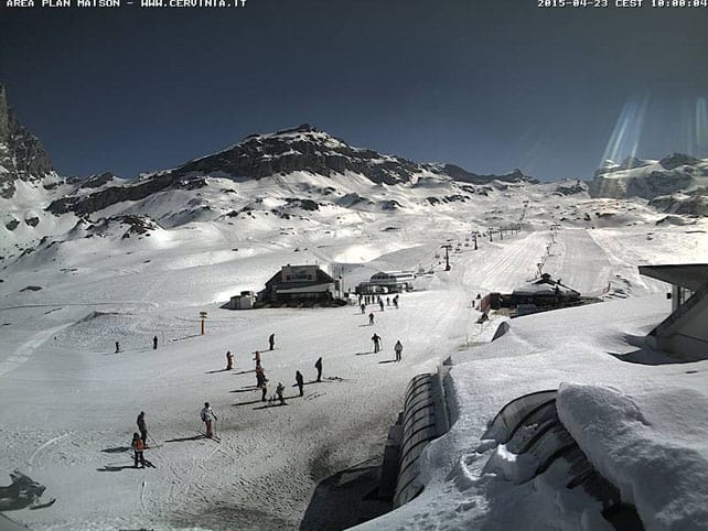
Below is how it’s looking in Cervinia. Here the snow is 40-250cm deep.
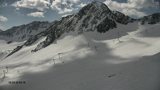
Finally, here’s the scene on the Stubai glacier today, where the sun is still out. There should, however, be some light snowfall here by the close of play. The existing cover is up to 260cm deep.
| France: this weekend will see the season boil down to just a handful of high-altitude ski areas in France. But if the forecast holds good, next week should see some excellent skiing there. While the snow falls, the visibility will be non-existent, of course, so you’ll need to be patient, but with fresh snow and empty pistes likely resorts such as Val d’Isere, Tignes and Val Thorens should be great fun once the skies clear. The Grands Montets sector above the Chamonix is another area that will be open next week. There, the snow is currently 90-175cm deep. | |
| Switzerland: as in France, the season is winding down fast in Switzerland, but there’s still plenty of snow at altitude, and there should be plenty more once this next spell of wet/snowy weather is over. Currently Zermatt reports a 240cm of snow at 2900m, while Engelberg has 220cm of mid-mountain snow, and 350cm at the top. | |
| Austria: parts of Austria will see fresh snow today – but the main event, snow-wise, will be the weather front that crosses the region between Sunday evening and Tuesday. Currently, on the Hintertux glacier, the snow is up to 290cm deep on the pistes. Meanwhile above Kaprun, the Kitzsteinhorn glacier reports snow 200-360cm deep. | |
| Italy: For the best snow, and the largest number of pistes still open, head to Cervinia, which shares its skiing with neighbouring Zermatt, and offers some of the highest slopes in the Alps. Here, the snow is 40-250cm deep. | |
| Andorra: Andorra’s ski resorts have now closed for skiing. | |
| Western USA: there was fresh snow in Utah last week, and a dump in Colorado at the weekend. There are likely to be snow showers over the next few days, too. But all the same, the ski season is winding down fast across the American west. Among the handful of resorts still open is Snowbird, Utah, where the mid-mountain cover is 188cm deep – not bad, considering local snow guru Evan Thayer reckons that, in terms of snowfall, this has been the worst-ever Utah season. Meanwhile, in Colorado, Arapahoe Basin reports 140cm of mid-mountain cover on its trails. | |
| Western Canada: April has been one of the best months, snow-wise, in western Canada this season, especially in the Rockies, where Lake Louise reports over a metre of snow since April 1. However, the weather’s turned spring-like now, and in Lake Louise the temperature on the slopes was up to +10C yesterday. Currently, the snowpack there is 149cm deep, and the lifts are due to shut on May 10. Meanwhile, nearer the coast, Whistler has now shut the lifts on Blackcomb mountain. They reopen to skiers on June 20 for the short glacier season. Whistler mountain will be open until May 18, and reports a mid-mountain snowpack of 176cm. |


Add Comment