


The snow’s coming. In the Alps, a lot of snow is coming. But it’s going to be accompanied by some wild weather: and a rocketing avalanche risk.
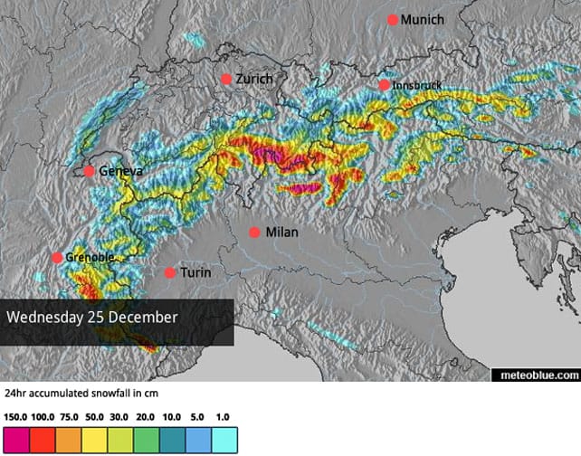
First of all, feast your eyes on the Welove2ski snow forecast for the Alps for Christmas Day.
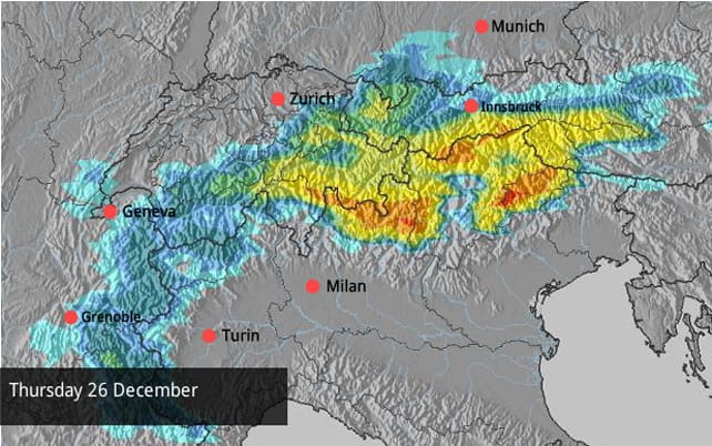
 And Boxing Day…
And December 27…

Personally, I find it hard to believe that up to 150cm of snow is going to fall in a single day – as predicted in a few spots on our Christmas Day map. But hey, I was wrong about the snow forecast last Thursday too. Thing is, even if these really monstrous accumulations don’t occur, it’s still clear the snowfall will be significant. Italy, Switzerland and Austria look set to get the lion’s share.
However, the snow will be preceded by a bout of wild and mild weather, which is going to make the going tough for anyone on the slopes this afternoon and tomorrow. French forecaster Meteo Chamonix is predicting tempestuous Foehn winds at altitude in the western Alps (there will be strong winds further east, too). It’s also predicting heavy rain at lower altitudes on Christmas Day below 1800m – before the rain/snow level drops to 600m on Boxing Day
The weather should calm down a bit on Friday, before another weather front socks in on Saturday. When skies eventually clear, there’ll be no more talk about thin snow cover – in the high-altitude resorts at least.
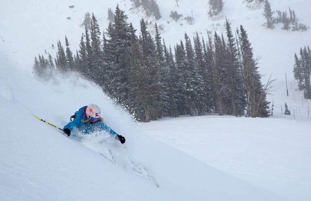
Expect dangerous conditions off-piste
All this snow is going to fall on one of the most unstable snowpacks for years – the product of all that mild and sunny weather in the first half of December. Check out the feature at pistehors.com for more on information on this, and if you’re planning to ski off-piste in the aftermath of the storm, hire a guide, check the avalanche forecast, and make sure you’ve got all the right equipment – including an avalanche airbag system if possible. You might want to read William Carey’s account of surviving an avalanche to get a bit of perspective too! Finally, once you’re out on the mountain, err on the side of caution at all times – and never put pressure on your guide to deliver an “epic day” if conditions don’t allow it. Stay safe!
There’s been more snow in American Rockies
There’s been plenty of snow in the American Rockies since Thursday. The Utah resorts have done particularly well, thanks to two snowstorms. The first, on Wednesday night and Thursday, brought 18cm of snow to the Canyons and 43cm to Powder Mountain. There was more snow at the weekend, though the goods were not evenly distributed. Most resorts report a dusting. But Snowbird had 25cm. Such are the vagaries of the Wasatch Mountains’ localised climate!
Jackson Hole in Wyoming had a good weekend too – reporting nearly 30cm of snow at the weekend.
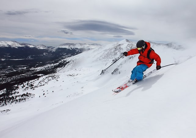
Peak 6 will open in Breckenridge on Christmas Day
One final piece of news: Breckenridge’s brand-new lift-serviced terrain, Peak 6, is opening to the public on Christmas Day. The Colorado resort reports 30cm of snow in the last week, and according to local snow supreme Joel Gratz there may be a little more on Tuesday. It looks as though the first turns up there on December 25 will be sweet ones!
Happy Christmas everyone!
| France: see our main report. The coming storm is going to transform conditions in the French Alps. The weather’s going to be wild and mild to start with, and once the snow comes the avalanche risk for off-pisters will go through the roof. But when everything settles down again it the skiing will be much improved. However, conditions will still be better in the higher resorts than the lower ones. Today’s snow depths seem hardly relevant given what’s about to come. But here there are anyway: Les Deux Alpes has 15-180cm of settled cover, on-piste, Val d’Isere has 43-80cm deep, Val Thorens has 60-100cm, Meribel 25-80cm and Alpe d’Huez 42-160cm. | |
| Switzerland: The snow’s pretty thin on the lower slopes of the Swiss resorts – but they’re likely to get a significant top-up thanks to the coming storm. However, the weather’s going to be pretty unskiable to start with – what with the high winds and white-out conditions. Be very careful if you’re heading off-piste over the coming week, too, as the avalanche risk will be high. Currently, in Laax the settled cover is 10-70cm deep, in Verbier it’s 18-85cm deep and in St Moritz it’s 20-23cm deep. | |
| Austria: With a few high-altitude exceptions – notably Obergurgl, the snow is thin in Austria at the moment. But the situation will have improved by the end of the week. Thursday and Friday look like the best day for fresh snow in many resorts – which will come just in the nick of time for the lower ski areas such as the Skiwelt. There, the snow is 25-45cm deep, depending on altitude. | |
| Italy: The Aosta valley and other areas in the western Italian Alps did very well from the localised snowstorms on Thursday. In Cervinia, for example, there was 45cm of fresh snow, and reports a mid-mountain snow depth of 65cm. According to our Snow Forecast, there should be plenty more snow here over Christmas, too. It looks as though the Italian Dolomites, further east, should also do well. | |
| Andorra: Thanks to heavy snow in November, the Pyrenees got off to a cracking start to the season. As in the Alps, early December saw mostly mild and sunny weather, but there was some snow last week, and a lot more is expected over Christmas. In Andorra, Grandvalira currently reports 90-170cm of settled snow, on-piste. | |
| Western USA: See our main report. Most Rocky-Mountain resorts have had fresh snow in the last five days – and the Utah resorts have done particularly well. By contrast, California has not been blessed, and is set for more dry weather for the next couple of weeks. Currently, Breckenridge has 97cm packed down, mid-mountain, Snowbird has a whopping 127cm, and Jackson Hole 104cm. There should be a little more snow in the Rockies in the run-up to Christmas. | |
| Western Canada: In Banff National Park, Lake Louise has had 60cm of fresh snow in the last ten days. The mid-mountain snowpack is 90cm deep, as a result. Further west, Whistler continues to get little top-ups of snow rather than big dumps, which have added up to 24cm in the last week. Mid-mountain, the cover is 95cm deep. |


Excellent news all round on the snow front today, but think hard before you go off-piste in Europe: https://t.co/EyKoEniSTf
Top story: Snow Report, December 23 | Welove2ski https://t.co/e0h0AnJSBP, see more https://t.co/oDOsFMb1hq