


The weather in the Alps has been stunning this week, but temperatures are rising, and the quality of the snow has suffered on low-lying and south-facing slopes.
Fortunately, more snow is forecast for the weekend. Where it will fall is not yet certain. Current forecasts predict moderate to heavy falls for France and Italy, but very little for Switzerland and Austria.
Good snow cover, bright sunshine, cloudless skies. That’s been the formula right across the Alps since Monday’s snowstorm cleared from Austria – and everyone’s a bit dazzled and loved-up as a result.
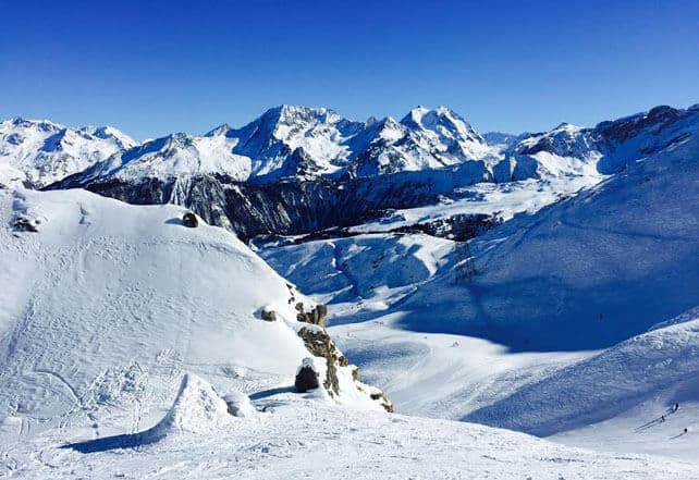
Here’s how it was looking yesterday in Courchevel, courtesy of British tour operator, Alpine Elements.
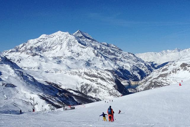
This was the Solaise, above Val d’Isere this morning.
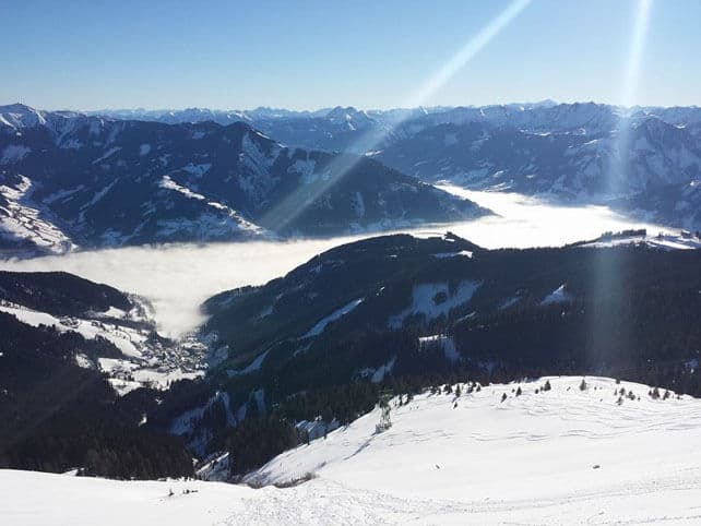
Pictured below was the view earlier this morning from the top of the Schmittenhohe, above Zell am See, in Austria.
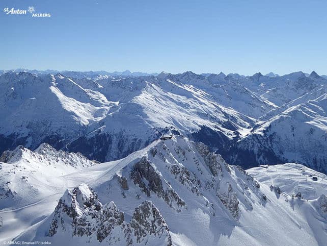
Here’s an aerial of the Valluga, above St Anton…
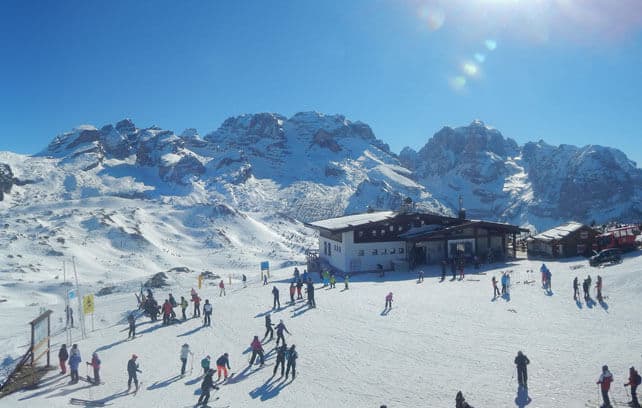
And these are the Brenta Dolomites, as seen from Madonna di Campiglio.
As regular Snow Report readers will know, there’s good skiing across almost all of the Alps at the moment, thanks several bouts of heavy snow in recent weeks. These include:
*A big storm over the central-southern Alps on January 18.
*30cm of fresh snow in Austria on January 27
*the “storm of the season” that hit France on January 29
*Piedmont and the Aosta Valley’s snowstorm of February 5-6
*Austria’s blizzard on February 9
The only area to have missed out on a dose of really heavy snow, so far, is the central core of the Italian Dolomites.
However, temperatures have been rising, and the freezing point today is at 2200-2300m across the Alps. That’s helping to settle the snowpack, off piste – to a degree. But it’s also affecting the quality of the cover at lower altitudes and on slopes that get a lot sun. Off-piste, breakable melt-freeze crusts are forming on south-facing slopes; on piste, you can expect the sunniest runs to be slushy in the afternoon, and then hard first thing the following morning.
The avalanche risk remains considerable in many areas. Poorly-bonded slabs of windblown snow, as well as discharges of wet snow on south-facing slopes are amongst the current dangers. The avalanche death toll is ticking upwards relentlessly at the moment, so please err on the side of caution.
It will snow this weekend
Here’s the current snow forecast for Saturday, which is looking good for the French and Italian Alps. Fingers crossed it doesn’t cause problems on the roads and airport runways…
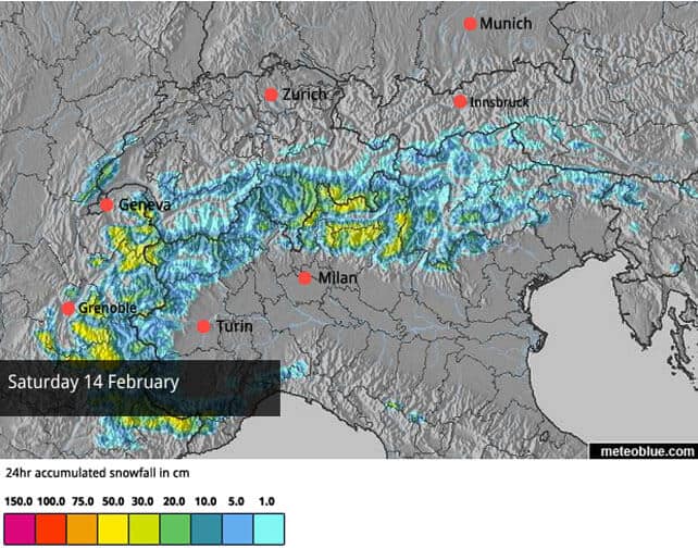
However, there is still some uncertainty as to exactly where the snow will fall, so this forecast may look a little different tomorrow. It’s also unclear what’s going to happen next week. Some models are predicting a second dose of snow on Tuesday. Others are showing a quick return of high pressure, and more spring-like temperatures. We’ll just have to wait and see.
In the American Rockies, change is in the air
It’s Women’s Giant Slalom day at the World Championships in Beaver Creek, Colorado and there’s excitement in the air. Not just at the prospect of more superb ski racing: but also because it looks as though winter will finally return to the Rockies next week. The last fortnight has been unusually mild across the region, but Sunday to Wednesday should see snow – just in time for the Presidents’ Day holiday on February 16.
| France: the weather’s been glorious this week, and the skiing’s pretty good too, although rising temperatures have affected the snow quality on low-altitude and sunny slopes. The fresh snow on Saturday should repair most of the damage, although the heavy traffic of half-term may scrape the steeper pistes back to their icy underlayer. Great caution is still required if you’re venturing off-piste.
Currently, Serre Chevalier – south of Grenoble – reports 40-150cm of snow on its pistes. Meanwhile, high-altitude Tignes has 90-155cm of cover, and Val Thorens has 105-160cm packed down, mid-mountain. Near Geneva, Avoriaz has some of the deepest snow in the French Alps, and reports 230-280cm of cover. |
|
| Switzerland: in Switzerland, the situation is similar to France. The cover’s generally good, but conditions are spring-like today, and the lower slopes are going through a daily freeze-thaw cycle. Resorts close to the Italian border should see snow this weekend, but elsewhere it’s likely to stay dry. Currently Verbier has 44-160cm of cover on its pistes, Laax in the east reports snow depths of 60-280cm, and St Moritz in the south has 45-129cm. | |
| Austria: Austria had its own private snowstorm on Monday, which added 20cm of fresh snow to many resorts. However, today’s spring-like temperatures, and strong sunshine, are affecting the quality of the cover lower down. Currently, in the Arlberg, Lech reports cover 90-175cm deep, and in the northern Tirol the Skiwelt has 80-100cm on its pistes. Meanwhile, in the east, Schladming reports 80-140cm of cover, on-piste. | |
| Italy: there was heavy snow across the Aosta Valley and Piedmont on last week, and it looks as though they’ll get more on Saturday when the next weather front arrrives. However, it’s the resorts slightly further east that will really benefit. Expect big snowfall totals in the likes of Madesimo, Livigno, Passo Tonale and Madonna di Campiglio. Currently, in the Dolomites, Canazei reports on-piste cover 20-115cm deep. Meanwhile, Madesimo is still reporting 170-430cm of snow on its pistes. Further west,Cervinia has 55-250cm of cover, on piste. | |
| Andorra: Andorra saw heavy snow last week: the Grandvalira ski area reckons it got 150cm of fresh, in the end, and reports settled cover, on-piste, of 100-170cm. | |
| Western USA: at last, it looks as though winter is heading back to the American Rockies, after a long, spring-like spell. A period of cold, snowy weather is expected to begin on Sunday night. Currently, Jackson Hole in Wyoming reports 198cm of settled snow, mid-mountain. In Utah, Snowbird in Utah has 175cm of mid-mountain cover, and in Vail, the settled snowpack is up to 114cm deep, mid-mountain. | |
| Western Canada: it’s been mild in western Canada too, with rain on the lower slopes of many resorts, and heavy snow higher up. Whistler reports 39cm of fresh snow over the last week at the top of its ski area. Today and tomorrow will bring more wet snow at altitude, as well as rain lower down. Even Lake Louise in Banff National Park has been feeling the heat. Top temperature at this usually cold resort should reach +4C today. Currently, its mid-mountain snowpack is 132cm deep. |


Can we have a snow report for Eastern Canada please??
We are travelling to Mont Tremblant 3rd March. It looks OK from their own website reports, but if you have someone ‘on the ground’ there it would be a bonus.
Thanks
Bob Leeson
Hi Bob! There’s good snow in Tremblant right now: but it’s cold cold COLD. Top temperature today should -23C. And tomorrow it won’t get above -27C! There’s a really sharp divide at the moment between the east and west of Canada. Resorts like Whistler are struggling with unseasonably mid temperatures: Tremblant is in the freezer. I would expect temperatures to be less Arctic by early March, though.