Hold onto your hats, everyone. The weather is about to get interesting in the Alps.
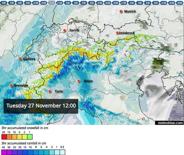
Heavy snow is expected in places, along with a sharp drop in temperatures. But it’s not going to be a straightforward event. First, there’s going to be a deluge on the southern side of the mountains – and only on the higher slopes will there be snow. Most of it will fall on the main Alpine ridge that doubles as the international border between Italy and the other Alpine nations. Some places, such as Pila, Saas-Fee, Madonna di Campiglio, and the upper slopes of Zermatt and Cervinia, could see well over a metre of the white stuff.
North of that line, a strong, warm, snow-eating Foehn is going to blow for a couple of days. Only a few resorts will get fresh snow – especially those close to the Italian border and south of Grenoble in France.
Check out our cloud/preciptitation forecast for the Alps for noon tomorrow (below) for an idea of how that’s going to look – and don’t forget to visit the next edition of the Snow Report, on November 29, for an update.

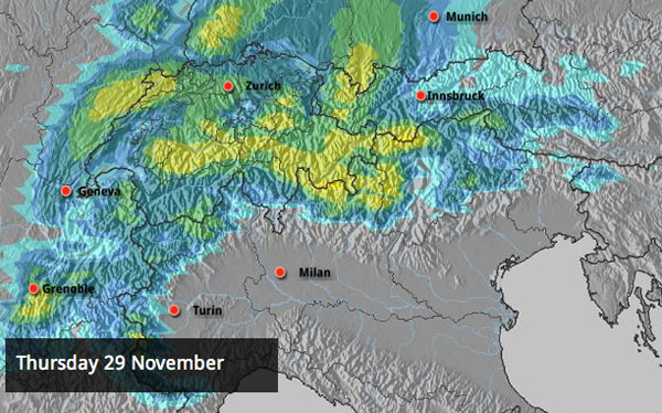
On Thursday, the temperatures will drop sharply, and there will be much more widespread snow falling across the north half of the region. In the French Alps, Meteo Chamonix expects the freezing level to be between 2200 and 2500m today, and 900-1100m on Friday, with snow down 600m. In Lech, Austria, they’re expecting highs of +6C today, -6C on Friday. Switzerland and eastern Austria will get the best of the snow, with over 30cm expected in places. Light snowfall should continue into the weekend, as well – keep an eye on our snow forecast to see how much.

Thereafter, the mid-range forecasts are predicting a sunny interlude, as a finger of high pressure creeps across the Alps from the west – followed by another blast of wintry weather, starting on December 6. Fingers crossed we get that second bout of snow. We can’t yet bank on a pre-Christmas powder party (except perhaps at altitude in Zermatt, Saas-Fee or Cervinia this weekend). After all, at this time of year it takes a lot of snow to cover the rocks off-piste. But once the temperature drops, the snow cannons will be working hard, and some places will get significant help from Mother Nature too. At the very least, conditions on piste will be good – or even excellent – as the mainstream season gets underway.
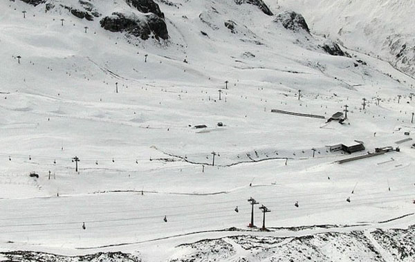
Don’t forget, Val d’Isere, St Anton and Les Deux Alpes are among the resorts opening this weekend. The lifts are already running in Val Thorens, Ischgl, Obergurgl and nearly all the glacier ski areas – as well as a few other resorts which got lucky in the pre-season snow lottery. The season is upon us!

Elsewhere in Europe, resorts are expecting a wintry blast too. Up in Scandinavia, temperatures have already dropped sharply – and Are in Sweden is expecting snow this week. At the weekend it opened its cable car for the first time – the earliest opening anyone can remember – which means top-to-bottom skiing is already possible (albeit on only a handful of pistes). The Pyrenees are expecting snow this week, too.

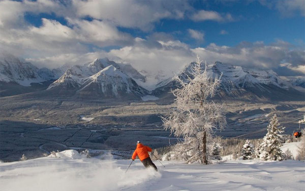
Meanwhile, in North America, the resorts of western Canada continue to enjoy the best early-season conditions. Since it opened on November 17, Whistler has had around 160cm of fresh snow on its upper slopes (although there has been some rain at resort level). Lake Louise and Sunshine Village in Banff National Park have had less snow – but in many ways the skiing has been more memorable, because the temperatures have been consistently low, and the snow – from the top to the bottom of slopes – has been cold, light and powdery. The fact that skiers have already enjoyed several powder days in Lake Louise’s back bowls – in mid-November – says it all, really.
There will now be a bit of a pause in the snowfall – and then a couple of big storms are due to hit the Pacific coast. The first should favour Whistler. The second is likely drag milder air across the western US – but is likely to give northern California a pounding in the process. The resorts around Lake Tahoe, including Heavenly, could be in for one of their occasional monster-snowfall moments. We’ll keep you posted.

| France: All eyes are on the skies this week. As we’ve said in our main report, it’ll be mild and Foehn-y at the start of the week, and then widespread snow is expected. It won’t be too heavy in the first instance: but there could be more next week. Val Thorens and Tignes is among the resorts already open. Val d’Isere and Les Deux Alpes are both slated to open on December 1. Above Chamonix, the Grands Montets will be the first ski area to open – on December 8. | |
| Switzerland: There’s good cover on the Swiss glaciers, although it has thinned quite a bit in the mild weather of the last fortnight days. On the Allalin glacier above Saas-Fee the cover is now 120cm deep – down from 165cm on November 15. In Zermatt, there’s skiing down to Schwarzsee and over into neighbouring Cervinia too. The upper slopes of both areas are due to get hammered by heavy, wet snow for the next three days. The glacier above Engelberg is also open for skiing as are a handful of pistes above Verbier. | |
| Austria: There’s been decent early-season skiing at Obergurgl, Obertauern, Ischgl and on the Austrian glaciers. But November has been marked by a two-week thaw and it’s clear it won’t go down as a classic. The upcoming snow should help rectify the situation. Only the resorts along the Italian border will get it at first, but there should be at least a dusting everywhere else later in the week. Hopefully there will be more to come starting on December 6. Among the glacier ski areas currently open are the Hintertux glacier the Molltal glacier, the Pitztal glacier, Kitzsteinhorn glacier, the Kaunertal glacier and the Stubai glacier glacier. You can also ski on both glaciers above Solden. | |
| Italy: In Cervinia you can now ski down to the mid-mountain hub of Plan Maison. You’ll be skiing blind for much of this week though, thanks to the heavy snow in the forecast. Still, once the skies clear, conditions will be sensational, given the time of year. Elsewhere, resorts are starting to open. In the east, Cortina d’Ampezzo opened on November 22, and Kronplatz on Saturday. Madonna di Campiglio is opening at the weekends, and is due to get heavy snow this week. Glacier skiing is possible again above Val Senales. | |
| Andorra: Andorra’s ski areas are closed. Fingers crossed the snow in the forecast comes this week. | |
| Western USA: Across the western US, conditions vary from disappointing to decent. In Wyoming, Jackson Holegot nearly a foot of snow on its opening weekend. It needs another dump or two before the powder pigs will be happy, though. In Utah, conditions are good, thanks to a couple of decent falls earlier in the month – but they need a top-up after the thaw. Colorado has missed out on much of the early-season snow and needs a favour or two from Mother Nature. In many resorts there, only a handful of trails are open.The next few days will be colder, and then milder temperatures will return at the end of the week: but there should be snow at altitude in the west and in the northern Rockies. In particular, the Lake Tahoe resorts of California are expecting a walloping from the storm. | |
| Western Canada: See main report. Right now, Canada has the best snow. Sunshine Village and Lake Louise in Banff National Park have the most consistent conditions. But powder pigs need to keep an eye on Whistler, which is due to get heavy snow again at the end of the week. |


Hold onto your bobble hats, everyone. The weather is about to get interesting in the Alps. https://t.co/yPxw2CLA
RT @welove2ski: Hold onto your bobble hats, everyone. The weather is about to get interesting in the Alps. https://t.co/yPxw2CLA
RT @welove2ski: Hold onto your bobble hats, everyone. The weather is about to get interesting in the Alps. https://t.co/yPxw2CLA
RT @welove2ski: Hold onto your bobble hats, everyone. The weather is about to get interesting in the Alps. https://t.co/yPxw2CLA
RT @welove2ski: Hold onto your bobble hats, everyone. The weather is about to get interesting in the Alps. https://t.co/yPxw2CLA
RT @ChaletsDirect: Good forecast – snow and wintry weather expected almost everywhere later this week! https://t.co/p5sWFUV9
RT @SnowAndRock: Lots of snow is coming to the Alps… #excited! https://t.co/o0dvZMKU
RT @SnowAndRock: Lots of snow is coming to the Alps… #excited! https://t.co/o0dvZMKU
RT @SnowAndRock: Lots of snow is coming to the Alps… #excited! https://t.co/o0dvZMKU
RT @welove2ski: Hold onto your bobble hats, everyone. The weather is about to get interesting in the Alps. https://t.co/yPxw2CLA
RT @SnowAndRock: Lots of snow is coming to the Alps… #excited! https://t.co/o0dvZMKU
RT @welove2ski: Hold onto your bobble hats, everyone. The weather is about to get interesting in the Alps. https://t.co/yPxw2CLA
Snow Report, November 26 https://t.co/SNpUDtOu
Snow Report, November 26 https://t.co/N9jtUlUX